
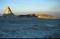
Ol Doinyo Lengai
| Ol Doinyo Lengai | ||
|---|---|---|
 During the 1966 eruption |
||
| height | 2960 m | |
| location | Tanzania , East Africa | |
| Coordinates | 2 ° 45 '49 " S , 35 ° 54' 52" O | |
|
||
| Type | Stratovolcano | |
| Last eruption | 2013 | |

The Ol Doinyo Lengai is an active volcano in the East African Rift Valley in northern Tanzania . It is located about 120 km northwest of Arusha on Lake Natron .
In the language of the Maasai means Ol Doinyo Lengai as much as the mountain of God . The approx. 2960 meter high volcano is the seat of their god Engai for the Maasai and the volcanic eruptions symbolize the god's wrath.
Volcanism
The Ol Doinyo Lengai is located above the so-called Tanzania craton and is the only active volcano in the world that produces carbonatite lava. This lava is very thin, about the viscosity of water. Recently solidified lava is dark in color that quickly turns to light beige. The natrocarbonatite lava (Na 2 CO 3 ) of this volcano reaches between 491 ° C and up to 590 ° C, a comparatively low temperature compared to the lava of other volcanoes , but comes from the earth's mantle.
The main production activity takes place in a crater lake area that is filled with the eruption products. The level of the filling is subject to constant change. The level of the carbonatite lava can suddenly drop and rise again. Gas bubbles with a diameter of up to 3 m are constantly forming. Often a lava flow is also carried over the crater rim. Steep cones with a height of up to a few meters, so-called hornitos , formed at smaller points of exit of the lava .
.jpg)
In July 2007 there was a large eruption with kilometer-high ash ejections, which led to the evacuation of the area and massively redesigned the summit area of the volcano. The explosive eruptions lasted until 2008 and formed a crater more than 100 m deep with steep walls. The vegetation has largely disappeared even on the mountain flanks.
In the crater there are several places where the typical carbonatite lava is ejected and smaller hornitos have already formed. If activity continues, the crater could refill over the years.
Routes to the summit
The volcano is rarely climbed because of its remote location and the lack of infrastructure. The ascent is technically easy, but very strenuous, as it runs without paths and in the upper area in up to 45 ° steep lava channels on the western flank of the volcano. Up to the edge of the crater, around 1,600 meters in altitude have to be overcome, and another 100 m to the highest point on the southern edge of the crater. Because of the high daytime temperatures, the ascent usually begins at night.
photos

Solidified lava in the crater of Ol Doinyo Lengai, August 2001
Oven or "hornito" in the volcanic crater, August 2001

View into the crater before the 2007 eruption, November 2006

View into the newly formed crater in January 2011

Lava ejection site in the crater, January 2011


.jpg)
.jpg)
Web links
- Ol Doinyo Lengai in the Global Volcanism Program of the Smithsonian Institution (English)
- Ol Doinyo Lengai. Pictures and panoramas in the Stromboli Online portalat SwissEduc.ch
- Ol Doinyo Lengai volcano on VolcanoDiscovery.com
- Ol Doinyo Lengai: The coldest lava in the world. Detailed information with photos and video on Vulkane.net
Individual evidence
- ↑ Maurice Krafft, Jörg Keller: Temperature Measurements in Carbonatite Lava Lakes and Flows from Oldoinyo Lengai, Tanzania. In: Science. 1989, doi: 10.1126 / science.245.4914.168 , PDF (English).
- ↑ Ol Doinyo Lengai Volcano - Eruption Effects. Geology.com (English) ( Memento of 10 July 2012 in the Web archive archive.today ).
- ↑ Ol Doinyo Lengai Volcano, Tanzania (Africa). VolcanoDiscovery.com, accessed August 17, 2012.