Olushandja Dam
| Olushandja Dam | |||||||
|---|---|---|---|---|---|---|---|
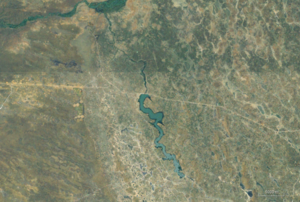
| The Olushandja dam (middle), with the Kunene and the Calueque dam (top left) | |||||||
|
|||||||
|
|
|||||||
| Coordinates | 17 ° 25 ′ 48 ″ S , 14 ° 39 ′ 0 ″ E | ||||||
| Data on the structure | |||||||
| Lock type: | Gravity dam | ||||||
| Construction time: | ? –1970 | ||||||
| Power plant output: | no power plant | ||||||
| Operator: | Namibia Water Corporation | ||||||
| Data on the reservoir | |||||||
| Water surface | 29 km² | ||||||
| Storage space | 42.331 million m³ | ||||||
The Olushandja Dam ( English Olushandja Dam ; also Etaka Damm , English Etaka Dam ) is a dam in Namibia , around 30 kilometers east of Ruacana and 120 kilometers northwest of Oshakati .
description
The Olushandja reservoir is fed with water from the Kunene and has a capacity of around 42.3 million cubic meters . With a surface area of 29 square kilometers, it is the largest in Namibia. He gives his water to the Calueque Oshakati Canal and the Etaka Canal. The natural drainage is formed by the Etaka , in whose valley the channel of the same name is laid.
function
The Olushandja dam was completed in 1990 as a gravity dam and is integrated into the Cunene project to supply water to north-central Namibia due to its water supply from the Calueque dam in Angola . In addition, it functions as a compensation basin within the canal system that has been developed here since the 1950s.
Individual evidence
- ↑ a b M. Amakali: Cuvelai Basin Management . Ministry of Agriculture, Water and Forestry (Namibia). 2006. PDF document p. 10 at www.iwrm-namibia.info.na ( Memento from 7 July 2015 in the Internet Archive ) (English)
- ^ Namibia Water Corporation Ltd [NamWater] :: Infrastructure: Dams: Olushandja ( Memento of February 19, 2012 in the Internet Archive )
- ^ South West Africa Administration. Water Affairs Branch: Ovamboland Master Water Plan . 1968. PDF document p. 78. on www.iwrm-namibia.info.na ( Memento from October 17, 2014 in the Internet Archive ) (English)

