
Hajar Mountains
| Hajar Mountains | ||
|---|---|---|
| Highest peak | Jebel Shams ( 2930 m ) | |
| location | Oman , United Arab Emirates | |
|
||
| Coordinates | 23 ° 13 ′ N , 57 ° 17 ′ E | |

The Hajar Mountains ( Arabic جبال الحجر Jibal al-Hajar , DMG Ǧibāl al-Ḥaǧar 'stone mountains') is the high mountain range that stretches from north to east of Oman . In the north, their foothills reach into the United Arab Emirates . It is also known as the Omangebirge . Besides the Dhofar Mountains in the south, it is the only mountain region in Oman.

location
The Hajar Mountains stretches about 450 kilometers from the border area between Oman and the United Arab Emirates to its easternmost headland, the Ra's al-Hadd , in the direction of the Indian Ocean . The Hajjar Mountains frame the coasts of the Gulf of Oman in a crescent shape and separate the fertile Batina coastal plain from the barren hinterland.
The Wadi Samail divides the Hajjar into an eastern and western mountain range. The wadi is the most important connection between the coast and the hinterland, as the rugged mountains are only passable in a few places. Therefore the main traffic route (motorway), the power and telephone lines, as well as pipelines run through the Wadi Samail. The western part of the mountain is also called al-Jabal al-Achdar and is the more important of the two. The two highest peaks of the Hajar Mountains are located here: the Jabal Shams , the "mountain of the sun", and the Jabal Kawr . The height of the Jabal sham is usually given as 3009 or 3017-3020 meters. Another prominent mountain in the western mountain range is the Jabal Misht , which, with its almost 1000 meter high southeast face, represents a challenge for mountaineers. The eastern part of the mountain, Hajar al-Sharqi , runs with decreasing height (1500 to 500 meters) to the eastern coast.
In the northern foothills of the Hajar Mountains lies the Jabal Yibir, the highest mountain in the United Arab Emirates.
geology
From a geological point of view, the Hajar Mountains are the continuation of the Zāgros Mountains and were mainly formed in the Miocene and Pliocene when the Arabian plate pushed against the Iranian plate. These mountains are mainly made up of chalk , limestone, and ophiolite .
Wadis

The flanks of the mountains are pretty steep and rugged, as there are hardly any promontories in many places. In some places rock valleys and canyons lead deep into the Hajjar Mountains. B. Wadi Tiwi and Wadi ash-Schab from the northeast coast, or Wadi Bani Khalid from the south. In these wadis there are rivers that at least partially carry water in winter. In Wadi ash-Schab and Wadi Bani Khalid, these mountain streams flow into freshwater ponds. In Wadi asch-Schab they are reached after 45 minutes' walk, in Wadi Bani Khalid a little earlier. Other wadis only carry water after rainfall. They mainly extend inland.
climate
Oman has an always hot subtropical climate that is humid and humid on the coasts and very dry in the interior. Winters are short and warm, the rest of the year hot. The Hajar Mountains are an exception in this regard: its higher-lying areas have a mountain climate. In contrast to other parts of Oman, the winters can be quite cold here, the summers are moderately warm and there is more abundant rainfall than usual. At night it can be very cool in all seasons, frost is rare and usually only occurs at altitudes above 2000 m.
Flora and fauna
The Hajjar Mountains have hardly any vegetation, which clearly shows the rock formations. The unfolding layers can be studied in detail in several places. This area is considered a paradise among geologists, all the more as it is one of the few places in the world where the meeting of the earth's mantle and crust is visible on the surface of the earth. The Hajar Mountains were formed during the Alpid mountain formation ( Alpid orogeny ) and are therefore one of the younger mountains in the world. The colors of the rock range, depending on the material, from ash gray or ocher to dark brown, red and black.
Some of the wadis are lushly lined with palm trees. Bushes and reeds also grow here. Otherwise you will only find rocks, stones, scree and dust over long distances, between which a tuft of grass or an acacia can only assert itself here and there . In the oases, wadis and basins, some of which extend into the mountains, vegetables, dates and citrus fruits thrive, also because of the irrigation system of the Falaj (plural Afladsch ). Here you can also find larger settlements such as Rustaq , Awabi and Nakhl on the coast or Ibri , Kubara , Bahla , Nizwa or Izki on the southwest flank of the Hajar, which slopes down towards the desert. At higher altitudes, rose growing plays a crucial role, which is of great importance to the Omanis, who are in love with fragrances, and which is practiced in mountain villages such as Misfah .
While its foothills serve as a living space for many people and are used intensively for agriculture, the Hajjar Mountains themselves (apart from remote, small mountain villages) are only sparsely populated. Here are the last retreats of the endangered Arabian Tahr , and the Arabian leopard has also been spotted here.

Rock region in the Jabal Shams area, seen from Wadi Ghul

The fort of Nakhl in a date palm that reaches up to the flanks of the Hajjar
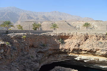
The Hawiyyat Nadschm sinkhole at the foot of the Hajar Mountains


Web links
- Southwestern Asia: Northern part of Oman on the WWF website