East-West Street (Breslau)

Ost-West-Straße ( Polish: Trasa Wschód-Zachód , Trasa WZ ) is the name of the inner bypass roads in Wroclaw that lead past the Great Ring and the inner old town .
course
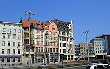
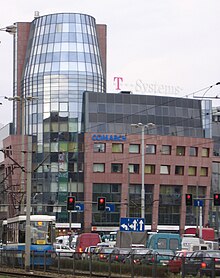
The expressway starts in the east at the Grunwald Bridge (formerly Kaiserbrücke) and leads over Społeczny-Platz, eastern Ohlauer Straße, Dominikanerplatz, Christophoriplatz, Kazimierz-Wielki -Straße, western Reusche-Straße and western Nikolaistrasse to Johannes-Paul-II. -Place (up to 2006 May 1st). A north branch of the street leads over Neue-Welt-Gasse and Weißgerbergasse, which have retained their names despite being merged into one large street. The street cross-section with a width of up to 60 m, which is unusually wide for the old town, can be explained by its development in the post-war period. The line consists of two lanes (two to three tracks), an intermediate own web body of the trolley (two tracks, locally three) and two partially level of free intersections with pedestrian underpasses and road tunnels (Dominikanerplatz) or street elevations (Społeczny Square). In addition, there are three other pedestrian underpasses along Schweidnitzer Strasse, at the former Outer Ohlauer Tor and at Johannes-Paul-II.-Platz. At present (2007) a shift of the through traffic from the east-west road to the planned old town ring is planned.
history
The Ost-West-Straße follows the former system of the inner city moat, the so-called Black Ohle . This artificial river, which was laid out at the beginning of the 13th century, lost part of its importance as early as 1263, as the city was expanded and the outer city moat was created, which took on the primary defense function. As a remnant of a fortification, it was used for urban drainage until the 19th century , and as a habitat for insects, it contributed to the outbreak of several epidemics . After a cholera outbreak , the moat was drained in 1866 and channeled according to the concept of Carl Johann Christian Zimmermann .
The first plans to build the street were made in the early 1920s, including a redevelopment plan for the old town that Max Berg worked on. The road was not built until 1977–1991, among other things according to a design by Andrzej Gretschel. The expressway combines two former streets running along the moat. The ruins of the houses that burned down in World War II between the dry city moat and the side streets were removed for this purpose. Several intact buildings were also torn down. The construction of the street severed the historic course of Schweidnitzer Strasse .
Buildings
Significant structures along Ost-West-Straße are:
- Postal check office in Breslau in the style of Brick Expressionism, designed and supervised by the government master builder and later post-builder Lothar Neumann (1891–1963) with ceramic reliefs by Felix Kupsch , built by Huta Hoch- und Tiefbau , 1927–1929
- Galeria Dominikańska , a business center of the ECE company , architect Edward Lach, 1999–2001
- Christophorikirche
- Bank building, architect Alvin Wedemann, 1909–1911
- Former royal palace
- Court Church
- University library
- Wratislavia Tower with the Helios cinema
- Former Holy Sepulcher Hospital
- Old armory
Individual evidence
- ^ Lothar Neumann: Das Postscheckamt in Breslau , Deutsche Bauzeitung, 65th year, 1931, page 61: http://delibra.bg.polsl.pl/Content/13795/no9_10.pdf
Coordinates: 51 ° 6 ′ 28.2 " N , 17 ° 1 ′ 49.1" E


