Big ring
The Great Ring or simply The Ring ( Rynek in Polish ) is a medieval market square in Wroclaw , which nowadays forms the core of the pedestrian zone . The ring has the shape of a rectangle measuring 205 m by 175 m. The development around the ring took place in different style epochs: The middle part of the ring is occupied by the step (a central block), which consists of the town hall , the new town hall and numerous town houses.
location
The ring forms an urban ensemble with the two diagonally adjoining squares - Salzring and Kirchenplatz near the Elisabethkirche . Eleven streets lead to the ring, two at every corner: Schweidnitzer Straße (ul. Świdnicka), Ohlauer Straße (ul.Oławska), Schlossstraße (now E. Gepperta), Reuschestraße (ul.Ruska), Nikolaistrasse (ul. Św.Mikołaja ), Oder Street (ul. Odrzańska), Forge Bridge (ul. Kuźnicza), Albrecht Street (ul. Wita Stwosza), as well as the 14th or 15th century. Broken rear market (Kurzy Targ) on the east side and two narrow back streets: Stockgasse (ul. Więzienna) and Dorotheengasse (przejście św. Doroty).
history
middle Ages
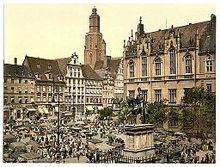
The ring was created when the city was re-founded according to Magdeburg law, according to the latest findings, under Heinrich I between 1214 and 1232. The older sources had only postponed the creation of the ring to the re-establishment in 1241–1242. It is also assumed that the two squares in Wroclaw's old town, the Great Ring and the Neumarkt further east, were created at the same time. In the 13th century, both squares were named forum . It was not until 1327 that a distinction was made between aldin markt (Großer Ring) and nuvin markt (Neumarkt). Over time, the Great Ring became more and more important for the city. With the construction of the town hall and the settlement of trading facilities, he was able to maintain his position in relation to the Neumarkt. The term ring was first mentioned for the square in 1350 in a jury book.
The first brick houses on the Ring were built as early as the 13th century. At first there was no basement and were probably free. In the 14th century, building activity increased on the Ring. The first two-story patrician houses with pointed roofs were built. In the middle of the 14th century, these already formed a closed edge development and the property boundaries were determined. Little by little, larger and larger residential and commercial buildings were built, mostly by merging several houses. Richly decorated facades and gables were attached to the front of the houses. After the great fire of 1363, the first Gothic houses were built on the Ring. These Gothic ornaments can hardly be seen today. In the 15th and 16th centuries, the fronts were redesigned in the Renaissance style.
The square itself was mainly used for markets.
19th century until today

In the 19th century tram lines ran through the ring - first a horse-drawn tram, then in 1892 an electric tram. The railways ran through the ring until the end of the 1970s and were then moved to the East-West Road . Around the turn of the 19th century to the 20th century, there were new, far-reaching changes to the ring. New commercial buildings were built, such as the Barasch Brothers department store in Art Nouveau style .
During the Second World War during the Battle of Breslau , almost 60% of the building structure on the Great Ring was damaged. 17 houses were largely preserved. After the war, the restoration of the partially preserved buildings began immediately. 24 houses were reconstructed, 11 rebuilt and 13 repaired again. The reconstructions were mostly based on the research carried out by Rudolf Stein in the 1930s. However, this often had to be improvised because many plans and drawings were missing or destroyed by the effects of the war.
In 1995 the modernization of the underground infrastructure on the Ring began. Archaeological investigations were carried out and various remains of old foundation walls were found, such as the city scales that were demolished in the mid-19th century. Between 1996 and 2000 the paving of the ring was redesigned by the architects Róża and Tomasz Myczkowski. Furthermore, the east side, the last drivable side, was closed to cars. Most of the facades were also renovated.
Today there are 60 numbered lots on the Ring, with some buildings taking up several parcels. The property divisions are mostly different from the original parceling, as there were subsequent subdivisions and amalgamations in the late Middle Ages. Each property has a traditional name, which is usually associated with the coat of arms visible on the facade or can be traced back to the history of the house, e.g. B. Under gripping , to the blue sun , old town hall .
The development of the Great Ring
Inner ring block
The central block is rotated 7 ° against the outer ring walls or the orthogonal street structure of the old town; the reason for this deviation is unclear.
The most important building on the Ring was always the town hall, built from the end of the 13th century. The ring was one of the few admissible trading places in the city; three large department stores were built there: the cloth house , the butter house (with bread and shoe banks) and the canvas house . In addition, several junk lines were created (Reichkrämer, Leichwandreissergang, Riemerzeile) and the houses of the large and the small scale. The cloth house had a two-aisled hall with a width of 13 m, which was flanked on both sides by 21 chambers. The chambers were accessible through doors from the hall and they lacked any lighting. Two chambers on the south side were intended for tax collectors, the remaining 40 for the cloth trade. The central hall was covered with a lowered roof towards the middle row of pillars, which probably had a barrel-like ceiling. The building line jumps back in the southwest corner of the central block - until the 18th century there was the fish market there, from 1745 the guard, which was replaced in 1788 by a larger building by Carl Gotthard Langhans .
After the repeal of the feudal Magdeburg town charter and the associated privileges, the old market facilities became superfluous. Therefore, the cloth house was torn down in 1821–1824 and replaced with two rows of classicist houses. At the same time the Butterfly House was demolished and its property was added to the houses in the Riemerzeile to the north. In 1847 the Große Waage was demolished in order to be able to build a riding monument of Friedrich II. In 1859 the Kleine Waage, the canvas house and the hop office gave way to the new town hall, which was built according to plans by Friedrich August Stüler . In place of the guard, a monument to Friedrich Wilhelm III. built. Both monuments were removed by the Poles shortly after World War II.
In 1956, the monument to the Polish playwright Aleksander Graf Fredro , evacuated from Lemberg and temporarily stored in Warsaw, was erected in front of the town hall, exactly in place of the Friedrich Wilhelm III monument . In 1988 the pillory east of the town hall was reconstructed (shortly after the war it was also removed as a feudalist penal instrument). In the 1960s and 1970s, the Teatr Laboratory of Jerzy Grotowski was located in one of the central log houses , nowadays the Grotowski Research Center is located there.
West side

The west side of the ring, also known as the Sieben-Kurfürsten-Seite , Tauben- or Paradeplatz , consists of most of the originally preserved architectural monuments, compared to the other outer sides. The Renaissance and Mannerist town houses were not damaged in World War II. The houses on the west side are also among the oldest on the Ring. The houses have very deep plots (240 feet) that reach down to Herrenstrasse (ul. Kiełbaśnicza). These properties, which belong to the wealthy Wroclaw patricians, were probably created through subsequent mergers.
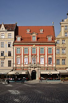
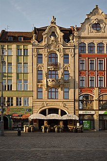
Building No. 1 was built during the Art Nouveau era (1907). The community center at Großer Ring 2, Unter den Greifen, is particularly valuable . With the high Mannerist gable, it forms the largest town house on the Ring. The building got its present form in the 16th century. The Lviv Inn (Karczma Lwówska in Polish) is located in the Zum Goldenen Adler house (No. 4). The Haus Zur Goldenen Sonne (No. 6) is one of the most beautiful and best-preserved buildings in the Baroque style on the Ring. The facade of the house Zur Blauen Sonne (No. 7) dates from 1902. The house was in ruins for a long time due to unclear ownership (it did not belong to the German citizens and was therefore not nationalized after the World War) and was only in the early 1990s renovated and its inner courtyard covered with a glass roof. It owes its name to the house to the seven electors (No. 8), whose history goes back to the 13th century. The building is also interesting because of its illusion painting, which was reconstructed in the early 1990s.
Instead of houses 9 to 11, a building for the Sparkasse (today Bank Zachodni WBK ), designed by the BDA architect Heinrich Rump, was built in 1931 and is still controversial today .
The area on the west side of the ring was called Parade Square from 1741, nowadays the name plac Gołębi ( Pigeon Square ) is sometimes used. On the west side of the ring, a controversial glass fountain was built in 2000, despite concerns about the preservation of monuments, which is called a urine basin based on the then mayor Bogdan Zdrojewski Zdrój ( source ) or because of its shape .
South side
The south side, also the golden cup side , was formerly called the side Beim Alten Galgen ( beym old gallows ). This site was almost completely destroyed in World War II. Therefore, today's buildings mainly consist of the houses reconstructed between 1952 and 1960, loosely based on their condition around 1800. These were rebuilt in the styles of the Renaissance , Baroque and Classical periods . A large part of them are department stores of the Art Nouveau era or New Building, which have pseudo-historical facades. The Art Nouveau facade of the Unterm Engel house (No. 13) survived the war without any significant damage. At the top of the house hangs a large angel looking down on the square. The Wroclaw Tourist Information Center is located in the house next door (No. 14). The rooms of house number 15 were used by the first Polish radio in 1945. House No. 16 was rebuilt in the Renaissance style in 1822. The Jewish merchant family Elias, from which the philosopher Norbert Elias comes, comes from this house .
The city's public place of execution was in front of the Haus zum Galgen (No. 19). The first mention of a house at this point comes from the 14th century. It was rebuilt at the end of the 19th century. The Schlesische Zeitung was moved to house number 20 . From 1519 there was a branch of the Schweidnitzer brewery in the house at the golden jug (No. 22). The building was connected to the Schweidnitz cellar via an underground passage . In 1900 the house was demolished and replaced by an Art Nouveau house. Destroyed in the war, it was rebuilt in its original condition from 1822. The house at the Golden Cup gave the south side its name. It had been in the possession of the Becher family since the 15th century. The facade of the house dates from 1909. A golden cup hangs above the entrance.
East Side
The east side or the Green-Röhr side is formed by the buildings Großer Ring 29 to 41 and is located opposite the main facade of the town hall. The site was named after a green fountain that no longer exists today. The Renaissance house Zur Goldenen Krone , built between 1523 and 1528, used to stand on property number 29 , which in 1908 had to give way to a department store . In the 1950s, this building, the street line of which was clearly sloping for traffic reasons, was given a pseudo-historical facade that was often described as poorly proportioned. In the 13th century the Gothic bailiwick house of the city was located in house No. 30 next door. This house was rebuilt in the baroque style at the beginning of the 18th century and turned into an inn. Among other things, August the Strong stayed here during his transit. Today the building is used by a McDonald's branch.
On the eastern side of the ring there are two more Art Nouveau department stores, both from 1904. House No. 31–32 is the large department store Gebrüder Barasch (now Feniks ) and was designed by Georg Schneider. House no. 39-40 is Louis Lewy by Leon Schlesinger. The Golden Dog House, which closes the ring side , was built after 1990 as the last restored building on the ring and was designed by Maciej Małachowicz.
North side
The north side, known as the Naschmarkt side , consists of parcels No. 42 to 60. The name comes from the 15th century and goes back to the confectionery that was previously sold here. The houses on the north side underwent major changes at the beginning of the 20th century and after 1945. Most of the town houses are just post-war rebuilds that deal with history very loosely.
The house Zum Goldenen Pelikan (No. 43) was rebuilt during the reconstruction after 1945 in the state of 1734. The house Zum Goldenen Hirschen is the most famous house on the Naschmarkt. The city's oldest pharmacy existed here until 1990. Today there is a Starbucks branch here.
The three neighboring plots 48, 49 and 50 form three department stores that were built by the architects Schlesinger & Benedict in the first decade of the 20th century. In the house at Zum Anker (Großer Ring 52) a Renaissance column has been preserved in the interior of the ground floor; the baroque house number 46 is an original monument.
The most famous café in town, Café Cukiernia, is located in the Zum Schwarzen Adler (No. 59) . The monument to the theologian Dietrich Bonhoeffer, who was born in Breslau, stands on the square in front of the Elisabethkirche .
Hansel and Gretel
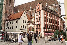
The north-western corner of the ring is occupied by two (actually three from a structural point of view) tiny altarist houses , which are connected to one another by an arched gate. In the past, the Elizabeth Church was surrounded by a closed ring of such houses, which shielded the churchyard from the streets. The houses were mocked as Hansel and Gretel (Polish: Jaś i Małgosia ) in the post-war period , but the name has now become official.
Web links
literature
- Cezary Buśko: Archeologia lokacyjnego Wrocławia. (online) (PDF; 2.4 MB)
- Olgierd Czerner: Rynek Wrocławski. Breslau 1976, DNB 1021265179 .
- Rudolf Stein : The Great Ring in Breslau. Priebatsch's Buchh., Breslau 1935, DNB 361716346 .
- R. Eysymontt et al. (2008): The Breslauer Ring. A city guide. Darbub Verlag, ISBN 978-83-61379-03-4 .
Individual evidence
- ↑ These dimensions are given by the Wroclaw monument conservator Rudolf Stein, information about 212 by 175 can be found, as well as the theoretical dimension 206.6 by 169 m (660 by 540 Breslauer feet per 0.313 m)
- ↑ Eysymontt, R. et al. (2008): The Breslauer Ring. A city guide. Darbub Verlag, ISBN 978-83-61379-03-4 , pp. 3-6
- ↑ Rudolf Stein was of the opinion that the first building built on the Ring, the department store, was deliberately rotated in order to dynamize the overall composition. Nowadays the most likely explanation is that the Cloth House was built before the city geometry was measured.
- ↑ In order to be allowed to work as a tanner or shoemaker, one was obliged to acquire a bank in the butter house. The corresponding craft regulations of King Sigismund (HRR) from 1420 says: First of all, the keyn shoemaker is not yet a tanner, he sy sat here or he came from a stranger in Stetten, should do his handicrafts, he then had eyn eygin bancke, whose name was meyster may...
- ↑ Eysymontt, R. et al. (2008): The Breslauer Ring. A city guide. Darbub Verlag, ISBN 978-83-61379-03-4 , p. 17
- ^ K. Klöppel: Breslau. 2014, pp. 43–45
- ^ K. Klöppel: Breslau. 2014 pp. 45–47
- ^ K. Klöppel: Breslau. 2014 p. 47
- ^ K. Klöppel: Breslau. 2014 pp. 48–50
Coordinates: 51 ° 6 ′ 37.4 ″ N , 17 ° 1 ′ 52.1 ″ E


