Otgon Tenger Uul
| Otgon Tenger Uul
(Otgon Tenger)
|
||
|---|---|---|
|
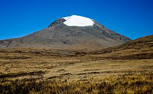
The Otgon Tenger from the east |
||
| height | 4008 m | |
| location | Dsawchan Aimag ( Mongolia ) | |
| Mountains | Changai Mountains | |
| Coordinates | 47 ° 36 '29 " N , 97 ° 33' 9" E | |
|
|
||
| First ascent | 1955 (Mongolian expedition) | |

The Otgon Tenger Uul ( Mongolian Отгонтэнгэр Уул ), or Otgon Tenger for short , in the Dsawchan Aimag of Mongolia is at 4008 m the highest mountain in the Changai Mountains and one of the highest mountains in the state. It is a sacred mountain of the Mongols and the only Changai mountain that, due to its height, has a permanent snow and firn field (east of the summit).
Geographical location
The Otgon Tenger Uul is located in the west of the Changai Mountains around 50 km east-southeast of Uliastai . About 14 kilometers west of the mountain extends to 2455 m height of the Chuch-Nuur ( Blue Lake ).
Mountain height
The Otgon Tenger Uul is so far given (depending on the source or map) with different heights between 3905 m and 4031 m. A survey ascent in September 2009 determined a height of 4008 m using GPS .
Ascent
The Otgon Tenger Uul was first climbed by a Mongolian expedition in 1955. Since 2003, there has been an ascent ban in the area of the snow and ice field near the summit, but this is regularly ignored, allegedly even by Mongolian politicians.
The ascent of the mountain is not difficult: from the east side a high valley rises up to 2500 m height at the foot of the mountain, which can be reached up to a few kilometers in front of it, for example with a motor vehicle. The easiest ascent is from the southeast side. You climb over a gravel and scree field, past a lake, up to around 3300 m on a high plateau. From there, an evenly formed scree slope extends up to the summit, which can be climbed at will. The variant on the left, which leads past the debris field of a crashed aircraft (see section Aircraft Accident ) at an altitude of around 3600 m, only reaches the 30 degree snow field very high up, around 200 m below the summit. The use of crampons is recommended. To the west, the mountain breaks off in a steep rock face with a height of up to 1000 m.
Plane crash
In 1963 an AN-24 of Mongolian Airlines crashed into thick fog on a domestic flight from Ulaanbaatar to Uliastai against the eastern flank of Otgon Tenger Uul. All 40 or so inmates were killed. Remains of the plane can still be found on the mountain today (2009).
Web links
- Otgon Tenger Uul , on summitpost.org (English)


