
Othelloplate


The Othelloplate is a sandbank in the southern North Sea , the area of which marks the eastern end of the East Frisian island of Norderney . The sandbar is located in the Lower Saxony Wadden Sea National Park .
Parts of the sandbar dry out at low tide . East, in the direction Baltrum , the sand adjacent to the with tonnes provided fairway of wichter ee .
Shipwreck
On December 2, 1967, the Emden herring logger "Ministerialrat Streil" ran aground on the south-east Hörn on the Othelloplate. An attempt was made to dredge a channel to the damaged vessel with the Schillsauger "Capella" lying in Bensersiel , whereupon the ship itself got stuck and was driven higher onto the beach by a subsequent storm. In February 1968, a tug was able to pull the herring logger back into the fairway during flooding, which was not possible with the "Capella". The wreck, which was exposed to the weather , has been lying in a bed of sand since then and has become a destination on Norderney.
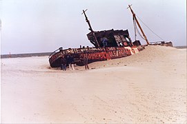
Decay of the wreck in 1977 ...

... and 2017


Ostbake
The east beacon is a five-meter-high wooden scaffolding on which a webcam is installed, with which you can watch the seals on the sandbank. Solar cells are used for power supply. The beacon is dismantled in the event of floods, strong storms or ice.
tourism
The shipping company Norden-Frisia offers an adventure trip to the seal banks in the summer months . From the north dike and the ferry terminal in the port of Norderney it goes south of the island in the Norderneyer mudflat to the Wichter Ee. At its western end, the Südosthörn, there is a seal bank on which seals and gray seals rest when the tide is low. The Seal Station North dike dismisses at this point among others reared Howler back to freedom.
See also
Web links
- Hans-Helmut Barty: The NBZ reader photo - 13.08.2015 . In: norderney-chronik.de . January 1, 2019. Accessed August 1, 2020.
- Hans-Helmut Barty: NBZ from May 13, 2020 . In: norderney-chronik.de . June 14, 2020. Accessed August 1, 2020.
Individual references and references
- ↑ Hans-Helmut Barty: Shipwreck at the end of the island . In: norderney-chronik.de . June 10, 2020. Accessed July 31, 2020.
- ↑ Hans-Helmut Barty: Norderney, Chronik einer Insel (1967). Accessed July 31, 2020 .
- ↑ A wreck that tells stories . In: Norderneyer spa courier - Christmas edition . 1985, p. 27 .
Coordinates: 53 ° 43 ′ 37 ″ N , 7 ° 20 ′ 49 ″ E