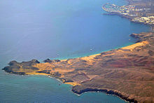
Papagayo beaches
The Papagayo beaches are located at the southwest end of the Canary Island of Lanzarote, which belongs to Spain , and belong to the municipality of Yaiza . They are at the end of the Rubicón plain, a few kilometers east of Playa Blanca . In 1402 the French Jean de Béthencourt and Gadifer de la Salle built the Rubicón fortification in this area .
The whole of the Playas de la Punta del Papagayo consists of the small bays:
- Playa El Papagayo
- Playa Puerto Muelas
- Playa Caleta del Congrio
- Playa de la Cera (Cerita)
- Playa de la Cruz or del Pozo
- Playa Mujeres
- Playa Caletón de San Marcial
You can reach them either on foot, by boat taxi from Playa Blanca or by car via sandy slopes. Since March 2nd, 1998, there has been a ticket booth with a barrier at the beginning of these slopes, where you have to pay a fee for each car. Where you could previously ski across the terrain, each slope is now limited by large boulders for environmental reasons. From the beaches you can see the neighboring islands of Fuerteventura and Lobos . Above, on the lava cliffs between the beaches of Playa Pozo and Playa de Papagayo, there is a beach restaurant.
Web links
- Ayuntamiento de Yaiza: Playas Punta del Papagayo. Ayuntamiento de Yaiza, 2018, accessed August 14, 2018 (Spanish).
Individual evidence
- ^ Antonio Tejera Gaspar, Eduardo Aznar Vallejo: San Marcial de Rubicón: la primera ciudad europea de Canarias . Artemisa, La Laguna 2004, ISBN 84-96374-02-5 , pp. 38 (Spanish).
- ↑ Playas. Ayuntamiento de Yaiza, 2018, accessed 2018 (Spanish).
Coordinates: 28 ° 50 ′ 52 " N , 13 ° 47 ′ 22" W.

