
Parc Jean-Moulin - Les Guilands
| Parc Jean-Moulin - Les Guilands | ||
|---|---|---|
|
|
||
.jpg)
|
||
| View from the north | ||
| Basic data | ||
| place | Bagnolet and Montreuil | |
| Created | 1980s | |
| Newly designed | 2001-2007 | |
| Surrounding streets | Rue Robespierre, Rue Charles Delescluze, Rue de l'Epine, Rue Hoche, Rue Désiré Préau | |
| use | ||
| Park design | Michel Pena | |
| Technical specifications | ||
| Parking area | 260,000 m² | |
| building-costs | € 6,250,000 | |
48 ° 51 '47.4 " N , 2 ° 25' 31" E
|
||

The Parc Jean-Moulin - Les Guilands is a park in the communities Bagnolet and Montreuil in Seine-Saint-Denis . The park has 1.8 million visitors annually. Originally the park consisted of two different parks - Jean-Moulin and Les Guilands - which were merged.
location
The Parc Jean-Moulin - Les Guilands covers a total of 26 hectares . It is located in two municipalities: the northern part is in the municipality of Bagnolet, the southern part in Montreuil. The park has a total of six entrances, three each in Bagnolet and Montreuil. The closest metro station is Gallieni .
history
Gypsum was mined on the site of today's park as early as the 17th century . In 1865 the first gypsum quarry was built. At the beginning of the 20th century, 60 tons of gypsum and 20,000 bricks were produced on the site by 250 workers every day. The plaster of paris was used to build numerous Haussmann-style houses throughout Paris. Gypsum mining ended in 1921 after numerous accidents and subsequent strikes.
In 1946 a motocross track was set up in the former quarries . This track was used for international competitions in the early 1950s. In the 1960s, construction of the A3 Autoroute through the quarry area began. During the construction work, the old quarries were partially filled up. In 1969 this car route was opened.
After the construction of the car route, the nearby residential areas should be protected from noise. That is why the Jean-Moulin Park was created in Bagnolet. At the same time, the municipality of Montreuil protected Les Guiland from building in the south . The southern part lay fallow in the following years, both areas were hardly used. Therefore, in May 2001, it was decided to combine both areas into one park and to redesign them.
In 2001, construction work began on the park designed by Michel Pena by the agency. It was officially opened in June 2007.
In 2011 an educational garden with an area of 1,300 m² was opened in the park. Various crops are planted in this garden. School classes and other groups can visit the garden.
A building ( Maison du parc ) was opened in the park in July 2016 and has since been used for various events such as parties.
layout
At the entrance through Rue Robespierre in Bagnolet is A la santé de la Révolution , a monument by the artist Jean Ipoustéguy to the French Revolution. It was built to celebrate the 200th anniversary of the revolution in 1989 and consists of three pyramid-shaped bronze pieces. The monument is illuminated at night.
In the center of the park, next to the Maison du parc, there is a 600 m long bridge ( La grande Traverse ) that connects the two parks. This bridge is almost completely covered with meadow.
The park also has a sports field with a running track and soccer field, as well as an artificial waterfall.
Natura 2000
There are some natural areas and a pond in the park. The park is part of the “ Natura 2000 in Seine-Saint-Denis ” network.
In the north and south of the park there are forests where various titmice such as the blue tit and other birds such as golden cockerel and small woodpecker breed. There are also fallow land for insects and birds spread across the park.
A pond should attract amphibians and provide a breeding place for insects.

Maison du parc

La grande traverse
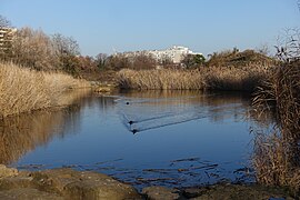
pond

waterfall

Running track and soccer field
.jpg)
.jpg)
.jpg)
.jpg)
.jpg)
Web links
- Parc Jean-Moulin - Les Guilands. In: parcsinfo.seine-saint-denis.fr. Seine-Saint-Denis Le Département, accessed on June 27, 2017 (in French, the park's website).
- Parc Jean-Moulin - Les Guilands. (PDF) In: parcsinfo.seine-saint-denis.fr. Seine-Saint-Denis Le Département, accessed June 27, 2017 (French, map of the park).
Individual evidence
- ↑ a b Le Parc des Guilands, Bagnolet, Montreuil - 0/0. In: penapaysages.com. Retrieved June 27, 2017 (French).
- ↑ a b c d Histoire et paysages. In: parcsinfo.seine-saint-denis.fr. Retrieved June 27, 2017 (French).
- ↑ LES PARCS, LES ESCAPES VERTS ET LES AIRES DE JEUX. (PDF (6.7 MB)) Ville Bagnolet , accessed on June 27, 2017 (French).
- ↑ - Le jardin pedagogique. In: parcsinfo.seine-saint-denis.fr. Retrieved June 27, 2017 (French).
- ↑ a b Espaces verts. In: ville-bagnolet.fr. Retrieved June 27, 2017 (French).
- ↑ INPN - FSD Natura 2000 - FR1112013 - Sites de Seine-Saint-Denis - Description. In: inpn.mnhn.fr. Retrieved June 27, 2017 (French).
- ↑ Les milieux. In: parcsinfo.seine-saint-denis.fr. Retrieved June 27, 2017 (French).