
Judge level


At 507 m, the Richterhöhe is the highest point on the Mönchsberg in Salzburg . The two kennels in the southwest of the Mönchsberg, the upper falcon kennel and the lower Bertholdszwinger are part of the historical fortifications of the mountain. They essentially come from the Middle Ages, but are sometimes mistakenly called Lodronsche Zwinger or Paris-Lodron-Zwinger after Prince Archbishop Paris von Lodron (1586–1653) . In 1906 the hill of the Upper Zwinger was named Eduard-Richter-Höhe in honor of the geographer, historian and alpinist Eduard Richter (1847–1905) , and in 1907 a memorial was erected there for him.
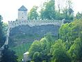
The Zwinger in the southwest of the Mönchsberg
The Lower Zwinger (Bertholdszwinger) blocks an easily accessible path to the Mönchsberg and was also designed as a side gate. The lower kennel is a four-walled area with two gates: If attackers should penetrate through the lower side gate, they could be fought from four sides in the area. The lower gate is in the Bertoldsturm (formerly called Florianiturm ), the upper one in Lodron's military guard house .
On the Richterhöhe (Oberer Zwinger, Falkenzwinger) are the Michaelsturm and the Josefsturm , both of which probably date from the 14th century. These towers were in the Neuzeut z. For a long time (mentioned in a document around 1724) it was used as a depot for powder. In 1831 the dilapidated medieval falcon tower collapsed and the Marien- or Kupelwieserschlössl was built in place of the earlier tower . A fourth tower, the small, preserved Barbaraturm , used to close the Upper Zwinger to the north.
Judge height today
The city of Salzburg has owned the site since 1905. The weir system was restored in the years after 2004.
A memorial to Eduard Richter , an Austrian geographer and glacier researcher, is located on the elevation ; therefore the term Richterhöhe is also used . The folk-song linden tree planted in 1931 by the choir of Salzburg secondary school students is also located here.
In 1908, on the initiative of the city council, a marble orientation table was built according to plans by Colonel E. Hettwers with a view of the surrounding mountains , which was recently restored by the City of Salzburg.
On the south-facing steep slopes of Möchsberg and Festungsberg outside the fortifications, z. T. Wine grown. This medieval use was the reason to create a small vineyard (0.25 ha) here by the boy scouts or a winery connected with the boy scouts in 2008; The Lower Austrian winery produces wine here for the Salzburg scouts and girl guides.
From the Richterhöhe you have a beautiful view to the south, of Leopoldskron Castle , the Salzburg basin and the surrounding high mountains.
More pictures
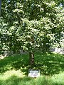
Richterhöhe: Volksliedlinde

lower kennel: Georgs defense tower with vineyard

Richter level: Orientation table with compass rose

Richterhöhe: View of the Hohensalzburg Fortress
Richterhöhe from the Hohensalzburg Fortress

Bürgermeisterloch on the way from the Zwingern to the Hohensalzburg Fortress


literature
- Heinz Dopsch ; Robert Hoffmann: Salzburg. The story of a city. 2nd updated edition. Verlag Anton Pustet, Salzburg, 2008. ISBN 978-3-7025-0598-1 . Pp. 309-314. (The book makes no reference to the buildings on Richterhöhe.)
Individual evidence
- ↑ Franz Schirlbauer; Franz Ruedl: Salzburg. Lasting values in good hands. 1862-1987. 1987, Salzburg: City Association Salzburg, p. 37.
- ↑ scout-guild Salzburg Maxglan [1] .
Coordinates: 47 ° 47 '36.7 " N , 13 ° 2' 25.3" E