Peña Hueva
| Peña Hueva | ||
|---|---|---|
|
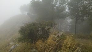
On the northern drop of the Peña Hueva |
||
| height | 972 msnm | |
| location | Guadalajara , Spain | |
| Mountains | Iberian mountains | |
| Coordinates | 40 ° 39 ′ 21 ″ N , 3 ° 6 ′ 24 ″ W | |
|
|
||
| rock | limestone | |
The Peña Hueva is a table mountain on the edge of the La Alcarria plateau in the central Spanish province of Guadalajara . The Peña Hueva is - like its northern neighbor, the Pico del Águila - just under 8 km northeast of the city of Guadalajara .
Characteristic
The mountain breaks off to the northwest through a distinctive and widely visible approx. 200 m high steep slope towards Guadalajara. The east and west slopes are less steep and overgrown with pine forest on the east side.
Ascent
The summit can be reached from the Valdenoches valley between Pico del Águila and Peña Hueva via forest roads.

