Peral (Illas)
| Municipality of Illas: Parroquia Peral | ||
|---|---|---|
| coat of arms | Map of Spain | |
 Help on coat of arms |
|
|
| Basic data | ||
| Autonomous Community : |
|
|
| Comarca : | Avilés | |
| Coordinates | 43 ° 29 ′ N , 5 ° 59 ′ W | |
| Height : | 360 msnm | |
| Area : | 6.9 km² | |
| Residents : | 234 (January 1, 2011) INE | |
| Population density : | 33.91 inhabitants / km² | |
| Postal code : | 33414 | |
| Area code: | 33030020000 | |
| Nearest airport : | Asturias Airport 18.7 km | |
| administration | ||
| Address of the municipal administration: | C / Callezuela nº1, 33411 - Illas | |
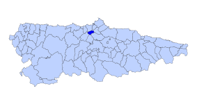
| Location of the municipality | ||

|
||
La Peral is one of three Parroquias and at the same time a place in the municipality of Illas in the autonomous region of Asturias in Spain .
geography
La Peral has 234 inhabitants (2011) on an area of 6.90 km². It lies at an altitude of 270–640 m above sea level. Illas, 3 km away, is the next larger town and also the administrative seat of the municipality.
The economic situation is almost entirely due to agriculture, with the López family's cheese dairy being known beyond Spain's borders for the Queso de la Peral .
The parish includes the
Villages and hamlets
- Argañosa 21 inhabitants 2011 43 ° 29 ′ 17 ″ N , 6 ° 0 ′ 34 ″ W
- La Peral 199 inhabitants 2011
- Reconco 11 residents 2011 43 ° 29 ′ 17 ″ N , 6 ° 0 ′ 5 ″ W
- Rozaflor 1 inhabitant 2011
Population development

|
| Source: website of the INE - graphical workup for Wikipedia |
Attractions
- San Jorge de La Peral Church
- Lopez family cheese factory
swell
- Population figures see INE
- For height information, see Google Earth
- Postcodes [1]
