Petersgroden
|
Petersgroden
Municipality Bockhorn
Coordinates: 53 ° 27 '16 " N , 8 ° 3' 45" E
|
|
|---|---|
| Height : | 1 m above sea level NHN |
| Postal code : | 26345 |
| Area code : | 04453 |
|
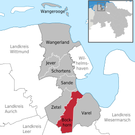
Map of Bockhorn
|
|
Petersgroden is a district of the municipality of Bockhorn in the Friesland district in Lower Saxony .
location
Petersgroden is located directly on the dike line of the Jade Bay and is the northernmost part of the municipality of Bockhorn.
history
The Groden settlement got its name from the Groden of the same name , which was diked from 1852 onwards. The dike on the 167 hectare area turned out to be extremely difficult, as the subsoil conditions were particularly poor. The levee, originally built to be 13 feet high , had already sagged two feet in 1853. In 1854, the dike was raised to 14 feet, but it had already sunk to 11.5 feet in 1860, so that it was necessary to raise it again.
literature
- Werner Brune (Ed.): Wilhelmshavener Heimatlexikon , Volume 1–3. Brune, Wilhelmshaven 1986–1987.
Individual evidence
- ↑ Werner Brune (Ed.): Wilhelmshavener Heimatlexikon , Volume 1–3. Brune, Wilhelmshaven 1986-1987, Volume 2, Page 515
