Pico Quioveo
| Pico Quioveo | ||
|---|---|---|
| height | 598 m | |
| location | Annobón , Equatorial Guinea | |
| Coordinates | 1 ° 26 '13 " S , 5 ° 37' 59" E | |
|
|
||
| Type | extinct volcano | |
| rock | basalt | |
| particularities | Second highest mountain on the island of Annobón | |
|
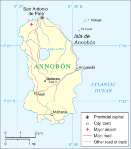
Map of Annobón with the location of Quioveo |
||
At 598 m, Pico Quioveo is the second highest point on the island of Annobón in the Gulf of Guinea , which politically belongs to Equatorial Guinea . The mountain is located in the center of the island, south of Lago Mazafim , the central crater lake of the island.
Annobón is a former volcano and comes from the same hotspot (" Cameroon Line ") that also formed the islands of Bioko , São Tomé and Príncipe as well as the Cameroon Mountain on the African mainland.
Web links
- Pico Quioveo on geonames.org (English)
- Pico Quioveo on peakery.com (English)

