Pico do Arieiro
| Pico do Arieiro | ||
|---|---|---|
|
Pico do Arieiro, north side, main peak center left |
||
| height | 1818 m | |
| location | Madeira , Portugal | |
| Coordinates | 32 ° 44 '8 " N , 16 ° 55' 44" W | |
|
|
||
|
View from Pico do Arieiro |
||
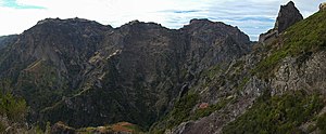
The Pico do Arieiro (also Pico do Areeiro ) is the third highest mountain in Madeira with a height of 1818 m . In contrast to the two higher peaks Pico Ruivo (1861 m) and Pico das Torres (1851 m), it is accessible via a road from the Poiso pass and is therefore the most visited peak on the island. Below the summit there is a large parking lot and a cafeteria with a souvenir shop to cope with the daily tourist flows, the pousada is falling into disrepair.
Immediately next to the summit is a radar station of the Portuguese Air Force that can be seen from afar .
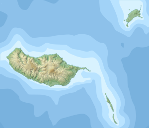
The neighboring island of Porto Santo , about 50 kilometers away, can then be recognized on the horizon, as can the Ilhas Desertas , which are closer . In autumn, thanks to the clear visibility, the Ponta de São Lourenço can be seen early in the morning , and in summer or later in the day it disappears in the mist of the rising damp of the vegetation. In winter there can be brief slippery road conditions due to snow and ice.
From the summit of Pico do Arieiro, a hiking trail leads around Pico das Torres to the highest peak on the island, Pico Ruivo . The hike takes two and a half to three and a half hours. It was a challenging mountaineering achievement until the 1960s. Due to the construction of secured stairways over the ridges and the tunnel through the Pico do Gato , it remains strenuous, but it is feasible for hikers with a moderate level of fitness, with a head for heights. In the middle section of the route, there is currently only the easier route through the Pico das Torres tunnel. The other variant across the ridge has been closed for two years due to slope breaks (as of January 2018).
From Pico Ruivo you can descend to Achada do Teixeira in an hour or to Boca da Encumeada in five hours , from where there is again a road connection.


