Piedra Sola
| Piedra Sola | ||
|---|---|---|
|
Coordinates: 32 ° 5 ′ S , 56 ° 19 ′ W Piedra Sola on the map of Uruguay
|
||
| Basic data | ||
| Country | Uruguay | |
| Department | Paysandú , Tacuarembó | |
| Residents | 210 (2011) | |
| Detailed data | ||
| Post Code | 45003 | |
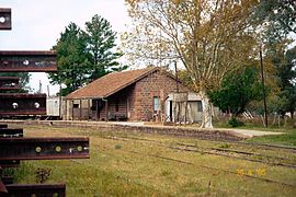
| Estación Piedra Sola | ||
Piedra Sola is a town in Uruguay .
geography
It is located in the area of the two departments Paysandú and Tacuarembó in their sector 6 and sector 2 respectively . Piedra Sola is located northeast of the village of Arbolito and south of Tambores in the Cuchilla de Haedo . The Arroyo Zapatero and the Arroyo Quillay rise north of the village . Nearest settlement to the east is the in Cuchilla de Aguará lying Curtina .
history
On October 15, 1963, Piedra Sola was given the status of " pueblo " by Law No. 13,167 .
Infrastructure
Piedra Sola is on the Salto - Paso de los Toros railway line .
Residents
For Piedra Sola, 210 inhabitants were counted as part of the 2011 census, 101 of them male and 109 female. 88 (41/47) lived in Tacuarembó and 122 (60/62) in Paysandú. In 2004, 211 inhabitants were registered (99 in Tacuarembó, 112 in Paysandú).
| year | Residents |
|---|---|
| 1963 | 332 |
| 1975 | 324 |
| 1985 | 286 |
| 1996 | 240 |
| 2004 | 211 |
| 2011 | 210 |
Source: Instituto Nacional de Estadística de Uruguay
Web links
- City map of Piedra Sola (PDF; 100 kB)
Individual evidence
- ↑ Postal code directory of the Uruguayan Post
- ↑ Statistical data from the Instituto Nacional de Estadística de Uruguay , accessed on September 23, 2012
- ↑ Statistical data from the Instituto Nacional de Estadística de Uruguay , accessed on September 23, 2012
- ↑ Statistical data from the Instituto Nacional de Estadística de Uruguay 2004 as an xls file
- ↑ Statistical data from the Instituto Nacional de Estadística de Uruguay 2004 as an xls file
- ↑ Statistical data of the Instituto Nacional de Estadística de Uruguay 1963–1996 (DOC; 148 kB)

