Pierres de Lecq
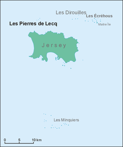
Les Pierres de Lecq ( Jèrriais : Les Pièrres dé Lé ) or Paternoster is a group of uninhabitable rocks or a reef in the Bailiwick of Jersey between Jersey and Sark , 6 km north of Grève de Lecq in Saint Mary and 22.4 km west of Cotentin in Normandy .
Only three rocks remain visible at high tide: L'Êtaîthe, La Grôsse and La Vouêtaîthe. The area has one of the largest tidal waves in the world, sometimes greater than 12 meters.
The name Paternoster is connected to a legend about the colonization of Sark in the 16th century. According to the legend, a boatload of women and children crashed on the reef, and their weeping can be heard from time to time in the wind. Superstitious sailors speak the Lord's Prayer when they pass the rocks, hence the name Paternoster .
The rocks are Ramsar territory and support a wide variety of small whales and dolphins . It is considered a kind of biogeographical boundary.
Names of rocks
(All names are in Jèrriais .)
- L'Êtchièrviéthe
- La Rocque du Nord
- L'Êtaîse or L'Êtaîthe
- Lé Bel
- Lé Longis
- La P'tite math
- La Grôsse (Great Rock)
- La Grand 'math
- La Greune dé Lé or La Bonnette
- La Greune du Seur-Vouêt
- L'Orange
- La Vouêtaîse , La Vouêtaîthe or La Vouêt'rêsse
- La Cappe
- La Douoche
- Lé Byi
- La Rocque Mollet
- L'Êtché au Nord-Vouêt
- La Galette
- La Briarde
- La Sprague
- La Niêthole Jean Jean or Lé Gouoillot
Footnotes
- Jersey Place Names , Jèrri, 1986, ISBN 0-901897-17-5
- Les Pièrres Dé Lé
Web links
- Ramsar Site (PDF file; 66 kB)
Coordinates: 49 ° 17 ′ 31 ″ N , 2 ° 12 ′ 9 ″ W.

