Herm (island)
| Herm | |
|---|---|
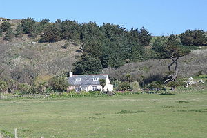
| Fisherman's Cottage on Herm | |
| Waters | English Channel |
| Archipelago | Channel Islands |
| Geographical location | 49 ° 28 '22 " N , 2 ° 26' 58" W |
| length | 2.4 km |
| width | 800 m |
| surface | 1.5 km² |
| Highest elevation | Monku 70 m |
| Residents | 79 (2015) 53 inhabitants / km² |
| main place | Le Manoir |
| Shell Beach on Herm | |
|
|||||
Herm is the smallest inhabited island of the Channel Islands and is part of the Bailiwick ( bailiwick ) Guernsey . The Channel Islands are neither part of the United Kingdom nor crown colonies , but as property of the British crown (English crown dependencies : Bailiots of Guernsey and Jersey) subject to the British crown.
geography
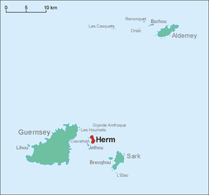
The island with a population of (together with the neighboring island Jethou) 79 inhabitants (2015) is 2.4 kilometers long and less than 800 meters wide. The northern half has sandy beaches, while the southern half is rocky. The steep cliffs in the south reach a height of 70 meters. The island of Jethou is immediately south. Small side islands and rocks mostly a few hundred meters from the coast are Meulettes, Moulinet (south), Selle Rocque, Putrainez (southeast), Caquorobert (east), Les Jacquets (northeast) and Hermetier (west).
Economy and Transport
As on the neighboring island of Sark , cars are not permitted on the 150 hectare island, nor are bicycles . The ban is circumvented by driving tractors and lawn mowers . The main source of income is tourism . Additional income is generated from the cultivation of vegetables and the occasional issue of their own stamps .
The island can be reached by boat from Guernsey.
The lease on the island was owned by Adrian Heyworth until mid-2008 . The new tenants are John and Julia Singer , who have been living on Guernsey since 1990.
history
Herm was settled as early as the Neolithic ; the prehistoric burial chamber The Common was discovered on the island . A monastery was built here in the 6th century. The name 'Herm' may be of the hermits (Engl. Hermits ) derived. Another possibility is the derivation of the Old Norse 'erm', since the island has the shape of an arm. In 709 such a violent storm raged that the flat piece of land between Herm and Jethou was washed away and one island became two.
In 933 the Channel Islands were annexed by the Duchy of Normandy . After the conquest of England in 1066, they were subordinated to the English royal family. Even after the English lost Normandy in 1204, the Channel Islands remained in the possession of the English crown. As a result, the monks gradually left the island. Between 1570 and 1737, Herm was the hunting ground of the Guernsey governors.
During the 19th century, granite was quarried to build fortifications on the other Channel Islands. The island was rented by the Crown to private individuals (including Compton Mackenzie from 1920–1923 ) and was usually not accessible. Before the First World War , a colony of wallabies was abandoned here by the tenant at the time ; none of the animals survived. The German Wehrmacht occupied the island during the Second World War.
administration
Administratively, Herm, like the neighboring smaller island Jethou, is a part of the parish ( parish ) St. Peter Port and belongs to the constituency of St. Peter Port South. However, it does not belong to any of the four cantons of St. Peter Port.
literature
- Eva Missler: Channel Islands. Jersey, Guernsey, Alderney, Sark, Herm. With a large travel card. 4th edition, completely revised and redesigned. Baedeker, Ostfildern 2007, ISBN 978-3-8297-1154-8 , p. 303.
- John Nettles : Hitler's island madness. The British Channel Islands under German occupation 1940–1945 . Osburg Verlag, Hamburg 2015, ISBN 978-3-95510-094-0 .
Web links
Individual evidence
- ↑ Guernsey Annual Electronic Census Report 31st March 2015 (English), p. 14, accessed on April 8, 2016 ( PDF ; 684 kB )
- ↑ Guernsey Election of States Deputies, 2008
- ^ Bailiwick of Guernsey
- ↑ St. Peter Port Parish, Canton Boundaries ( Memento of the original from October 6, 2011 in the Internet Archive ) Info: The archive link was inserted automatically and has not yet been checked. Please check the original and archive link according to the instructions and then remove this notice.


