Chapayev Peak
| Chapayev Peak | ||
|---|---|---|
|
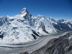
View from the northeast over the Northern Engiltschek Glacier : Khan Tengri in the foreground on the left; on the right in the background the peak of Chapayev |
||
| height | 6371 m | |
| location | Ak-Suu Raion in Issyk Kul ( Kyrgyzstan ) | |
| Mountains | Tengritoo ( Tian Shan ) | |
| Dominance | 3.28 km → Khan Tengri | |
| Notch height | 520 m ↓ West-Sattel ( 5851 m ) | |
| Coordinates | 42 ° 11 '58 " N , 80 ° 8' 18" E | |
|
|
||
| First ascent | 1937, I. Tjutjunnikow | |
The Pik Tschapajew (or Tschapajewa ; English Chapaeva ) is a mountain in the Tian Shan in Kyrgyzstan .
location
The 6,371 m high Pik Tschapajew is located in the Tengritoo ridge , which runs between the northern and southern Engiltschek glaciers. The peak Tschapajew has a 6,120 m high northeastern secondary peak. A mountain ridge leads from this to Khan Tengri, 6,995 m high and 3.28 km east-northeast . The 5851 m high west saddle separates the two mountains.
Origin of name
The mountain was named after Vasily Ivanovich Chapayev , a commander of the Red Army in the Russian Civil War .
Ascent history
The peak of Tschapajew was first climbed by I. Tjutjunnikow in 1937.
Web links
- Peak Chapayev at Peakware
- Photo of the south wall at summitpost.org
- more photos at summitpost.org
- Black and white photo at bandwmag.com
- Photo by Khan Tengri and Pik Tschapajew at leninpeak.net
- Mountain panorama at climbingguidebg.com
cards
- Sheet 0/15 Khan Tengri - Tien Shan, Kyrgyzstan , Alpine Club Map 1: 100,000
Individual evidence
- ↑ Yevgeniy Gippenreiter, Vladimir Shataev: Six and Seventhousanders of the Tien Shan and the Pamirs (PDF (4.6 MB)) Alpine Journal, 1996, 122-130.

