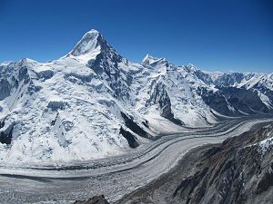
Khan Tengri
| Khan Tengri - Chan tengri | ||
|---|---|---|
|
Northern view of Khan Tengri |
||
| height | 7010 m (without ice cap 6995 m) | |
| location | Border triangle Kazakhstan , Kyrgyzstan , PR China | |
| Mountains | Tengritoo ( Tian Shan ) | |
| Dominance | 19.88 km → Gengish Chokusu ( Pik Pobeda ) | |
| Notch height | 1685 m ↓ ( 5310 m ) | |
| Coordinates | 42 ° 12 '39 " N , 80 ° 10' 27" E | |
|
|
||
| First ascent | 1931 by Pogrebetzki | |
| Normal way | from the southern Engiltschek glacier over the western flank | |
| particularities | highest mountain in Kazakhstan | |
|
Overview map of the Engiltschek area with Khan Tengri |
||
The Khan Tengri ( Mongolian , "Khan of Heaven" or "Heavenly Ruler"; derived from Old Mongolian: Khaghan-Tengri ; Turkish : Tanrı Han ) is a 7010 m high mountain in the Tian Shan Mountains in Central Asia . It is recognized as 7000m although without its ice cap it would be a rocky peak of 6995 m . At the culmination point, the borders of Kazakhstan , of which it is the highest peak, meet Kyrgyzstan and China .
geography
The characteristic pyramidal Khan Tengri is the second highest mountain in the Tian Shan after the 7439 m high Dschengisch Tschokusu ( Pik Pobeda ) located about 20 kilometers south . It is the northernmost seven-thousander on earth. Despite its enormous height, it is not located on the main ridge of the Tian Shan, but in the Tengritoo ( Tengri-Tau ), a ridge that descends from east to west and divides the Engiltschek glacier ( Inyltschek glacier ) into two arms.
history
In 1856 the mountain was identified by the Russian geographer and biologist Pyotr Semjonow and considered by him to be the highest peak of the Tian Shan. Only later was the Dschengisch Tschokusu recognized as the highest peak of the mountains.
The access to Khan Tengri was already found at the beginning of the 20th century by the German geographer and alpinist Gottfried Merzbacher , who initially reached the large ice reservoir , later called Merzbacher Lake , which made an ascent over the northern branch of the Engiltschek Glacier impossible . Therefore, he turned to its southern basin and was able to penetrate into the immediate vicinity of the mountain that he called "ruler of the Tian-Shan". Merzbacher determined the height of the mountain to be 7200 m .
In 1931 the Ukrainian mountaineer Mikhail Timofejewitsch Pogrebetzki made the first ascent together with Boris Tyurin and the Austrian Franz Sauberer, who lived in the Soviet Union. Their route from the southern Engiltschek glacier over the western flank is still the easiest and represents the normal route. The second ascent was made in August 1936 by a group from Alma-Ata in Kazakhstan. The third ascent took place in September 1936 by Vitali and Yevgeny Michailowitsch Abalakow as well as Leonid Gutman, Michail Dadiomow and the Swiss Lorenz Saladin .
The Austrian mountaineer Toni Dürnberger died on August 17, 1992 on Khan Tengri.
Well-known routes on the mountain include the normal route, the aesthetically beautifully curved southwest ridge (called "Serp" or "sickle"), the east ridge and the south face. The most difficult leads are on the almost 3000 meter high north face. In August 2005, Pawel Schabalin and Iljas Tuchwatulin succeeded for the first time in climbing the wall in two-man alpine style.
Only in the last few years has it been proven beyond any doubt that the summit exceeds the 7,000 m limit - but only with its ice cap; the rock below geologically only reaches 6995 m . Nevertheless, it is recognized as a 7000er.
In 2000 the Kazakh mountaineer Denis Urubko climbed Khan Tengri from the base camp ( 4000 m ) to the summit ( 7010 m ) in just 7 hours 40 minutes.
The mountain is one of the five seven-thousand-meter peaks on the territory of the former USSR . The Snow Leopard Order is given to the climbers who have conquered all five peaks.
On August 26, 1999, the presidents of Kazakhstan, Kyrgyzstan and the People's Republic of China signed a border agreement that finally regulates the historically unclear border between the two Central Asian states and China. It was decided to place the point at which the borders of the three countries meet on the summit of Khan Tengri.
Web links
- Hantengri Feng, Kazakhstan / Kyrgyzstan on Peakbagger.com (English)
Individual evidence
- ^ Alpenvereinskarte 0/15, Khan Tengri . Published in the context of the Alpine Club cartography by the German Alpine Club 2011 (1: 100,000).
- ^ Hans Dieter Sauer: The rediscovery of an explorer . In: Bavarian Academy of Sciences (Hrsg.): Akademie Aktuell . No. 1 , 2007, p. 63–66 ( badw.de [PDF; accessed March 19, 2019]).
- ↑ Gottfried Merzbacher: The Tian-Schan or the Himmelsgebirge . Sketch of a research trip carried out in 1902 and 1903 to the central Tian-Schan. In: Journal of the German and Austrian Alpine Club . 1906, p. 121 ff . ( Available online in the Austrian National Library [accessed on March 15, 2013]).
- ↑ Robert Steiner ; Emil Zopfi : Death on Khan Tengri. Lorenz Saladin, expedition mountaineer and photographer. AS Verlag, Zurich 2009
- ↑ Toni Dürnberger in the Historical Alpine Archives of the Alpine Clubs in Germany, Austria and South Tyrol (temporarily offline)
- ^ Section: Sino-Central Asian Boundaries in: Strategic Analysis. A Monthly Journal of the IDSA, January 2001, Vol. XXIV, No. 10


