Ciężkowice Mountains
| Ciężkowice Mountains | ||
|---|---|---|
|
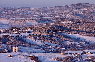
Brzanka ridge in winter |
||
| Highest peak | Liwocz ( 562 m npm ) | |
| location | Poland | |
| part of | Mittelbeskiden foothills | |
|
|
||
| Coordinates | 49 ° 51 ′ N , 21 ° 5 ′ E | |

The Ciężkowice Mountains (Polish: Pogórze Ciężkowickie ) consists of foothills of the Central Beskids in southern Poland in the Lesser Poland and Subcarpathian Voivodeships . Its highest peak is the Liwocz with 562 m. It is named after the city of Ciężkowice .
geography
The mountains border on the Rożnów Mountains in the west, the Strzyżów Mountains in the east, the Jasło-Krosno Basin in the south and the Tarnów Plateau in the Sandomir Basin in the north . It lies between the Biała rivers in the west and Wisłoka in the east.
structure
The mountains have an area of 740 km² and are divided into several ridges, of which the Brzanka ridge is the most important.
Cities
The towns in the Ciężkowice Mountains are Ciężkowice , Biecz , Pilzno , Jasło and Tuchów . The city of Tarnów to the north can be clearly seen from the mountains .
tourism
Numerous marked hiking and cycling trails run through the mountains.
War cemeteries
At the beginning of the First World War, bitter fighting raged in the mountains between the advancing Russian army and the army of Austria-Hungary. Therefore, there are numerous military cemeteries from the First World War here.
natural reserve
The mountains are located in the Ciężkowice-Rożnów Nature Park . There are two nature reserves:
- Skamieniałe Miasto Nature Reserve
- Liwocz nature reserve
- Ostry Kamień Nature Reserve
- Łąki nad Młynówką Nature Park
proof
- Jerzy Kondracki: Geografia regionalna Polski . Warszawa: Wyd. Naukowe PWN, 1998. ISBN 83-01-12479-2


