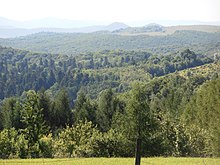
Przemyśl Mountains
| Przemyśl Mountains | ||
|---|---|---|
|
Southeast of the mountains |
||
| Highest peak | Suchy Obycz ( 618 m npm ) | |
| location | Poland | |
| part of | Mittelbeskiden foothills | |
|
|
||
| Coordinates | 49 ° 36 ' N , 22 ° 39' E | |
The Przemyśl Mountains (Polish: Pogórze Przemyskie ) consist of foothills of the Central Beskids in southern Poland in the Subcarpathian Voivodeship . Its highest peak is the Suchy Obycz with 618 m. It is named after the town of Przemyśl , which is located in the north of the mountain.
geography
The mountains border in the west on the Dynów Mountains , in the east it extends to the Ukrainian border, where it merges into the East Beskids , in the south on the Sanok-Turka Mountains and in the north on the San Dniestr plateau . It lies between the San to the west and Wiar to the east.
structure
The mountains are divided into several ridges.
Cities
The only major city in the Przemyśl Mountains is Przemyśl . Sanok is located on the southern edge of the mountains .
tourism
Numerous marked hiking and cycling trails run through the mountains.
War cemeteries
At the beginning of the First World War, bitter fighting raged in the mountains between the advancing Russian army and the army of Austria-Hungary. The Battle of the Przemyśl Fortress (part of the Battle of Galicia ) took place near the mountain from 1914 to 1915 .
natural reserve
The mountains are located in the Przemyśl Mountains Landscape Protection Park , which will soon be converted into the Turnicki National Park (Polish: Turnicki Park Narodowy ). There are numerous nature reserves in the park:
- Brzoza Czarna w Reczpolu Nature Reserve
- Broduszurki Nature Reserve
- Kalwaria Pacławska nature reserve
- Kopystanka nature reserve
- Kozigarb Nature Reserve
- Krępak Nature Reserve
- Leoncina nature reserve
- Przełom Hołubli Nature Reserve
- Reberce nature reserve
- Turnica Nature Reserve
proof
- Jerzy Kondracki: Geografia regionalna Polski . Warszawa 1998: Wyd. Naukowe PWN, ISBN 83-01-12479-2


