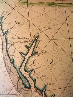
Pomeroon (river)
| Pomeroon | ||
|
van Keulen Atlas from 1688 |
||
| Data | ||
| location | Guyana | |
| River system | Pomeroon | |
| origin | Confluence of several streams 6 ° 55 ′ 9 ″ N , 59 ° 1 ′ 0 ″ W |
|
| muzzle | In the Atlantic Coordinates: 7 ° 37 ′ 54 ″ N , 58 ° 44 ′ 19 ″ W 7 ° 37 ′ 54 ″ N , 58 ° 44 ′ 19 ″ W
|
|
The Pomeroon is a river in Guyana . It lies between the Orinoco and the Essequibo and was also a Dutch colony in the 17th century .
The small colony on the Pomeroon was founded by Zeeland countries and the settlement consisted of a few houses, the place Nieuw Middelburg and the Fort Nova Zeelandia . From here, the settlers mainly traded with locals . In 1689 all the buildings and the fort were destroyed by French privateers . It was not until the end of the 18th century that the area was settled again by the Dutch and plantations were created on the banks of the Pomeroon. The river was now part of the Essequibo colony - and Demerara . The river basin was conquered by the British in 1796, briefly returned to Dutch hands through the Peace of Amiens from 1802 to 1803, after which it was taken over again by the British. From 1831 the Pomeroon was part of British Guiana .
