
Port Kembla
| Port Kembla | |||||||
|---|---|---|---|---|---|---|---|
 Aerial view of Port Kembla |
|||||||
|
|||||||
|
|||||||
|
|||||||
|
|||||||
|
|||||||

Port Kembla is an industrial suburb about eight kilometers south of the city of Wollongong in the Illawarra region of the Australian state of New South Wales and had a population of about 5,000 in the 2016 census. The name "Kembla" is borrowed from the language of the natives and means something like "many wild birds". James Cook mapped the coast here as early as 1770 .
Port Kembla is home to a seaport and one of Australia's largest industrial complexes, once known for the BHP steel mill . BlueScope Steel , a company separated from BHP, still produces steel on site for the national market. The place is increasingly exemplary for the progressive de-industrialization of the fifth continent.
In 2011, around 10% of the population said they were born in the former Yugoslav Macedonia and 4% in Italy. The median income is around two thirds of the New South Wales average. Unemployment is high. The median price for houses with three bedrooms in November 2015 was around AUD 410,000, the corresponding rent per week was AUD 380.
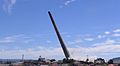
De-industrialization: chimney blast 2014

View of Sublime Point 2015

Defense system from the Second World War

Platform on the train station


Individual evidence
- ↑ a b Australian Bureau of Statistics : Port Kembla ( English ) In: 2016 Census QuickStats . June 27, 2017. Retrieved February 7, 2020.
- ↑ Port Kembla Property Market, House Prices & Suburb Profile , Realestate.com.au, as of November 2015.