Port Mathurin
| Port Mathurin | ||
|---|---|---|
|
|
||
| Coordinates | 19 ° 41 ′ S , 63 ° 25 ′ E | |
| Basic data | ||
| Country | Mauritius | |
|
Dependent island |
Rodrigues | |
| ISO 3166-2 | MU-RO | |
| Residents | 8050 (2016) | |
|
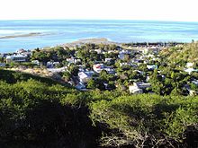
Port Mathurin Panorama
|
||
Port Mathurin is the capital of the island of Rodrigues in the Indian Ocean , which belongs to Mauritius . With 8,050 inhabitants (as of 2016) it is the largest city and the administrative, economic and cultural center of the island.
geography
Port Mathurin is on the north coast of the island. Mountains in the hinterland protect the city from the southeastern trade winds . The size of the city center is about 600 by 300 meters. Overall, however, include 22 towns ( localities ) of the city:
- Baie Lascars (North)
- Camp du Roi
- Castor
- Cavern Provert
- Citronelle
- Crève Coeur
- Désiré
- English Bay
- Fond La Digue
- Jentac
- Mont Piton
- Mont Vénus
- Montagne Charlot
- Montagne Fanal
- Pointe Canon
- Pointe Monnier
- Port Mathurin
- Roseaux
- Solitude
- Soupir
- Terre Rouge
- Vangar
Immediately adjacent to the main town are Fond La Digue, Montagne Fanal, Pointe Monier, Camp du Roi and Baie Lascar.
history
On May 1, 1691, a group of Huguenots who had fled France , led by François Leguat , landed in Mathurin Bay. In 1735 the first permanent settlement on Rodrigues of France was established here. The place name comes from one of the first settlers Mathurin Bréhinier . In 1810 the British fleet assembled in Mathurin Bay to invade the islands of Réunion and Mauritius. In 1901 a telegraph cable was installed through the Indian Ocean to Australia, the maintenance center of which was in the city.
economy
The port of Port Mathurin is the only one on the island and therefore serves to supply all of Rodrigues. It is called at about once a month by two ships belonging to the Mauritius Cargo Handling Corporation . Like the entire island, the harbor is protected from the open sea by a coral reef . Shops only sell essential products, everything special must be ordered directly in Mauritius.
education
Since 1973 there has been a high school in town, Rodrigues College .
religion
There is a Catholic and an Anglican church and a small mosque in the village .
Web links
Individual evidence
- ↑ Mauritius: Districts, Cities & Towns - Population Statistics, Maps, Charts, Weather and Web Information. Retrieved April 5, 2018 .
- ↑ List of localities within each zone defined for Rodrigues ( Memento of the original of March 10, 2010 in the Internet Archive ) Info: The archive link was inserted automatically and has not yet been checked. Please check the original and archive link according to the instructions and then remove this notice.
- ^ Alan Mountain, Alain Proust: This is Mauritius. Verlag Struik 2000, ISBN 1-84330-301-9 , p. 38.


