
Possession Islands
| Possession Islands | ||
|---|---|---|
 |
||
| Waters | Ross Sea , Southern Ocean | |
| Geographical location | 71 ° 56 ′ S , 171 ° 10 ′ E | |
|
||
| Main island | Possession Island | |

The Possession Islands (from English possession , property ' ) are a group of small islands and surf rocks off the Borchgrevink coast of the East Antarctic Victoria Land . They extend over an area of eight miles in the western section of the Ross Sea at a distance of about eight miles southeast of Cape McCormick .
It was discovered during the Antarctic expedition (1839-1843) of the British polar explorer James Clark Ross . With the naming, this commemorated the taking over of the islands for the British Empire by hoisting the Union Jack on January 12, 1841 on the main island of Possession Island .

Possession Island with Dickson Pillar (left)

Point of Possession Island
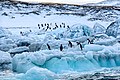
Adelie penguins on Possession Island
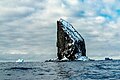
Kristensen Rocks cliff


Web links
- Possession Islands in the Geographic Names Information System of the United States Geological Survey (English)
- Possession Islands on geographic.org (English)