
Kristensen Rocks
| Kristensen Rocks | ||
|---|---|---|
 |
||
| Waters | Ross Sea , Southern Ocean | |
| archipelago | Possession Islands | |
| Geographical location | 71 ° 55 ′ S , 171 ° 11 ′ E | |
|
||
| Number of islands | 2 | |

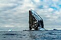
The Kristensen Rocks are two cliff rocks off the Borchgrevink coast of East Antarctica Victoria Land . In the group of Possession Islands , they are 1.5 km south of Possession Island .
The United States Geological Survey mapped them on the basis of their own measurements and aerial photographs of the United States Navy from 1960 to 1963. The Advisory Committee on Antarctic Names named them in 1969 after the Norwegian captain Leonard Kristensen (1857-1911), who together with Henryk Bull and Carsten Egeberg Borchgrevink in the course of the Antarctic voyage carried out from 1894 to 1895 on January 24, 1895 at Cape Adare, who supposedly set foot on the Antarctic mainland for the first time.

Kristensen Rocks double stone gate
Kristensen Rocks


Web links
- Kristensen Rocks in the Geographic Names Information System of the United States Geological Survey (English)
- Kristensen Rocks on geographic.org (English)