
Prappach

Prappach is part of the district town of Haßfurt in the district of Haßberge in the administrative district of Lower Franconia in Bavaria .
geography
.jpg)
The parish village is on the edge of the Haßberge, which gave the district its name. It is at an altitude of about 230 m above sea level. NN and has 695 inhabitants (as of July 1, 2006).
The Franconian Marienweg leads through Prappach .
history
The first documentary mention comes from the year 1109.
On May 1, 1978, the previously independent place was incorporated into the district town of Haßfurt.
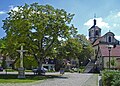
Attractions
- Baroque village church with a massive tower from the 16th century and remains of a cemetery fortification system (Häckerstein).

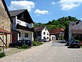


Half-timbered house in Prappach

Half-timbered house in Prappach Wachthügelstraße 14


Individual evidence
- ^ Federal Statistical Office (ed.): Historical municipality directory for the Federal Republic of Germany. Name, border and key number changes in municipalities, counties and administrative districts from May 27, 1970 to December 31, 1982 . W. Kohlhammer GmbH, Stuttgart and Mainz 1983, ISBN 3-17-003263-1 , p. 759 .
Web links

Augsfeld | Hassfurt | Mariaburghausen | Oberhohenried | Prappach | Sailershausen | Sylbach | Uchenhofen | Unterhohenried | Wülflingen
Coordinates: 50 ° 3 ' N , 10 ° 34' E