
Puig de les Cadiretes


The Puig de les Cadiretes is with 518.7 meters the highest mountain in Massís de l'Ardenya in Catalonia in the field of city Tossa de Mar .
location
Even if the Puig de les Cadiretes is the highest mountain in the mountains, it can hardly be seen from a distance. While the mountains of the coastal range are wild and steep from the coast, but also from the interior ( Costa Brava means "wild coast"), the slopes around the Ermita de Sant Grau are no longer as strong. The mountains here form a slowly rising mountain range from east to west, the Serra de Sant Grau, the highest point of which is the Puig de les Cadiretes. From the north (e.g. from the neighboring Montagut (498.3 m)) it forms only a small elevation of a mountain range. From the south (here the road from Tossa de Mar to Llagostera is the closest contact to human development), the Puig de les Cadiretes is shielded by a semicircle of mountains that are smaller, but look like the Massís de l from the perspective of the surrounding towns 'Determine Ardenya.
The mountain
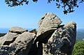
The summit of the Puig de les Cadiretes can be reached from the GI-6821 road. About two kilometers after the Ermita de Sant Grau (in the direction of Llagostera) a hiking trail Passejada fins al Puig de les Cadiretes branches off to the right , which leads to the summit in about two kilometers. On the summit there is a fire alarm tower ( Punt de Guaita per la Vigulancia d`incendis forestals ) with the identification E-301. In the dry season, this tower is manned by an observer who can report forest fires immediately. Next to the tower, one of the rocks that make up the summit is used as a viewing platform. From both you have a wide view over the Massís de l'Ardenya, the Mediterranean Sea, the Girona plain , the neighboring Massís de les Gavarres and, in good weather, to the Pyrenees .
Despite its remoteness, there are traces of human presence on the mountain since ancient times. Halfway to road GI-6821 is a menhir with a stone age stone grave. There are remains of walls from the Iberian era on the summit . The drawings on some rocks on the summit, which date from the Middle Ages, are more recent.

Puig de les Cadiretes as seen from Montagut . The Puig de les Cadiretes can only be recognized as a small point

Badge of the Instituto geografico

Viewing platform
Summit of the Puig de les Cadiretes


swell
- Heights according to the Mapa Topogràfic de Catalunya 1: 10,000 of the Institut Cartogràfic de Catalunya ( Puig de les Cadiretes - Topographic map of the area at the Cartographic and Geological Institute of Catalonia.)
- Information board at the fire alarm tower and the signpost for the hiking trail
Web links
Coordinates: 41 ° 45 ′ 26.2 " N , 2 ° 55 ′ 41.8" E