Puka (Estonia)
| Puka | |||
|
|||
| State : |
|
||
| Circle : |
|
||
| Coordinates : | 58 ° 3 ' N , 26 ° 14' E | ||
| Area : | 200.9 km² | ||
| Residents : | 1,881 (2006) | ||
| Population density : | 9 inhabitants per km² | ||
| Time zone : | EET (UTC + 2) | ||
| Community type: | former rural community | ||
| Website : | |||

|
|||
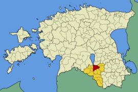
Puka (German: Bockenhof ) is a former rural community in the Estonian district of Valga with an area of 200.9 km². It had 1,881 inhabitants (January 1, 2006). The administrative seat was in Puka. In the course of the municipal reform in 2017, the rural municipality of Puka was dissolved and divided between the three rural municipalities of Otepää (Valga County), Tõrva (Valga County) and Elva ( Tartu County ). The villages Kähri, Kibena, Kolli, Komsi, Kuigatsi , Meegaste, Plika, Põru, Prange, Puka, Ruuna and Vaardi came to Otepää, Aakre, Palamuste, Pedaste, Purtsi, Pühaste and Rebaste to Elva and Soontaga to Tõrva.
The landscape with numerous forests and avenues is particularly interesting for nature tourists.
On May 1st, 1897, one of the greatest railway disasters in Estonia occurred in Puka, killing 58 people and seriously injuring numerous others.
Web links
- Website of the municipality of Puka (Estonian)
- Puka in pictures


