Pywycha
| Pywycha | ||
|---|---|---|
|
Pywycha |
||
| height | 169 m | |
| location |
Poltava Oblast , Ukraine |
|
| Coordinates | 49 ° 11 '36 " N , 33 ° 7' 32" E | |
|
|
||
| Age of the rock | Young Pleistocene | |
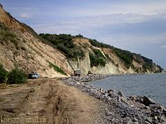
The Pywycha ( Ukrainian Пивиха , Russian Пивиха Piwicha ) is a 169 m high mountain in the Ukrainian Oblast of Poltava . The mountain is a geological and historical reserve.
Geographical location
The Pywycha located on the southern outskirts of the village Hradysk on the left bank of the kremenchuk reservoir dammed Dnepr .
history
The mountain was created as a result of a glacier system located here during the Dnepr Ice Age (corresponds to the Saale Ice Age in northern Central Europe). In the mountain there are outcrops of blue marl , a rare silicate clay component .
Since the 17th century there was a monastery on the mountain, which became an important religious and political center and played an important role in the fight against uniatism . In 1786 the monastery was closed and secularized.
After the damming of the Dnepr to the Kremenchuk reservoir in 1960, whose waves can reach a height of seven meters in a storm, the mountain is exposed to gradual destruction. The mountain has had the status of a local natural monument since 1969 . The area of the nature reserve is 165.2 ha .
Web links
Individual evidence
- ↑ Mount Pywycha, Hradysk: Photos, history, location on Doroga.ua , accessed on August 2, 2015. (Ukrainian)
- ↑ Mount Piviha on kolokray.com , accessed on August 2, 2015. (Ukrainian)


