Kremenchuk reservoir
| Kremenchuk reservoir | |||||||||||
|---|---|---|---|---|---|---|---|---|---|---|---|
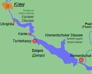
| Site plan of the Kremenchuk reservoir | |||||||||||
|
|||||||||||
|
|
|||||||||||
| Coordinates | 49 ° 13 ′ 21 ″ N , 32 ° 39 ′ 9 ″ E | ||||||||||
| Data on the structure | |||||||||||
| Construction time: | 1959-1961 | ||||||||||
| Data on the reservoir | |||||||||||
| Water surface | 2252 km² | ||||||||||
| Reservoir length | 149 km | ||||||||||
| Reservoir width | 28 km | ||||||||||
| Storage space | 13.5 km³ | ||||||||||
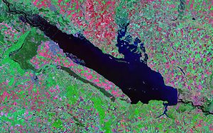
| Landsat image of the reservoir | |||||||||||
The Kremenchuk reservoir ( Ukrainian : Кременчуцьке водосховище ) is one of the six large Ukrainian reservoirs on the Dnieper .
The central Ukrainian oblasts of Cherkassy , Kirovohrad and Poltava border the reservoir .
The Kremenchuk reservoir covers an area of 2252 km² and contains about 13.5 km³ of water. Its length is 149 km with a maximum width of 28 km. At the deepest point the water has a depth of 28 m. It is of great importance for fishing . There are also large fish farms on the shore of the lake in the area of the Hlobyne Rajons .
The dam of the lake stands about 15 km west of the city of Kremenchuk near the city of Svitlovodsk . There is a large hydroelectric power station here . Territorial road T – 17–03 runs along the top of the dam. The dam was built between 1959 and 1961.
In the course of the damming of the Kremenchuk reservoir , many residents had to be resettled. a. flooded the city of Novoheorhiyivsk . Most of them moved into apartments in new settlements planned by the Soviet state on the banks of the dammed lake.
The Sula and Tjasmyn rivers flow into the reservoir .
Larger cities on the Kremenchuk reservoir are the Oblast capital Cherkassy and the city of Switlovodsk .


