Kachowka Reservoir
| Kachowka Reservoir (Kachowka HES) | |||||||||||
|---|---|---|---|---|---|---|---|---|---|---|---|
| Site plan of the Kachowka reservoir | |||||||||||
|
|||||||||||
|
|
|||||||||||
| Coordinates | 47 ° 28 ′ 0 ″ N , 34 ° 10 ′ 0 ″ E | ||||||||||
| Data on the structure | |||||||||||
| Construction time: | 1950-1955 | ||||||||||
| Height of the barrier structure : | 37 m (wall), 22 m (dam) | ||||||||||
| Building volume: | 640,000 m³ (wall), 21,500,000 m³ (dam) | ||||||||||
| Crown length: | 3 629 m | ||||||||||
| Data on the reservoir | |||||||||||
| Water surface | 2155 km² | ||||||||||
| Reservoir length | 240 km | ||||||||||
| Storage space | 18200000000 m³ | ||||||||||
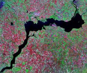
| Landsat image of the reservoir | |||||||||||
The Kachowka reservoir ( Ukrainian Каховське водосховище / Kachowske vodoschowyschtsche ; Russian Каховское водохранилище / Kachowskoje vodochranilishche ) is located in the southern Ukraine on the lower reaches of the Black Sea on the Dnieper River . It has a size of 2155 km² and holds 18.2 billion m³ of water.
Occasionally one finds the wrong information that the Kachowka reservoir contains 182 billion cubic meters, making it the largest reservoir on earth (but only after Lake Victoria ). But here one was wrong by a factor of 10 (see web link below).
The reservoir was created from 1947 to 1955 below the town of Zaporizhia and is named after the town of Kachowka on the bank . It is located in the three Ukrainian administrative districts of Dnipropetrovsk , Zaporizhia and Kherson . Because of its enormous dimensions, it is also known as the "sea". It took two years to fill the 240 km long reservoir. Its water is used for irrigation and enables the cultivation of wine, fruit and rice.
Kachowka HES
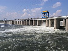
The Kachowka HES dam and hydropower plant ( Ukrainian Каховська Г ідро Е лектро С танція / Kachowska H idro E lektro S tanzija ) is located near Nowa Kachowka and consists of a combination of a gravity dam with a dam made of bulk material. Together they are 3629 m long, of which the dam is said to have 2970 m and the wall 437 m (which does not add up to exactly 3629 m). The T-47 territorial road , which connects the two Dneprufer with each other, runs over the dam . The power plant belongs to the Ukrainian company "ОАО Ukrhidroenerho" ( Укргідроенерго ).
geography
After leaving the dam, the Dnieper runs west, passes Kherson and flows into the Black Sea. Above the Kachowka reservoir near Zaporozhye there is another reservoir ( Dneprostroi or "Dnjepr reservoir") with a hydroelectric power plant, the "DniproHES". The Dnepr-Kryvyi Rih Canal and the North Crimean Canal begin at the reservoir and carry drinking water to the city of Kryvyi Rih and the Crimean peninsula .
Cities on the lakeside
The town of Nikopol with a port and the towns of Tawrijsk , Kachowka, Kamjanka-Dniprowska , Enerhodar , Dniprorudne and Marhanez and the urban-type settlements of Wessele , Wassyliwka , Novoworonzowka , Welyka Lepetycha and Hornostajiwka are located on the reservoir .
See also
See also: List of dams in the world


