Kryvyi Rih
| Kryvyi Rih | ||
| Кривий Ріг | ||
|
|
|
| Basic data | ||
|---|---|---|
| Oblast : | Dnepropetrovsk Oblast | |
| Rajon : | District-free city | |
| Height : | 84 m | |
| Area : | 410 km² | |
| Residents : | 624,579 (2019) | |
| Population density : | 1,523 inhabitants per km² | |
| Postcodes : | 50000 | |
| Area code : | +380 564 | |
| Geographic location : | 47 ° 55 ' N , 33 ° 21' E | |
| KOATUU : | 1211000000 | |
| Administrative structure : | 1 city , 7 city rajone , 2 villages, 4 settlements | |
| Mayor : | Yuri Wilkul | |
| Address: | пл. Радянська 1 50101 м. Кривий Ріг |
|
| Website : | http://www.kryvyirih.dp.ua/ | |
| Statistical information | ||
|
|
||
Krywyj Rih ( Ukrainian Кривий Ріг ; Russian Кривой Рог Krivoy Rog ) is a city in southern Ukraine with about 625,000 inhabitants (2019). After Dnipro, it is the largest city in the Dnipropetrovsk Oblast and the center of the Kryvbass , a large iron ore mining area with a resident mechanical engineering , food and chemical industries , steel smelting and the extraction of uranium . Among other things, the third largest company in Ukraine , Kryworischstal, is based here .
Krywyj Rih is the cultural center of the Krywyj Rih agglomeration with a theater , museums and universities, including the National University of Krywyj Rih, founded in 2011 . In addition, Krywyj Rih is the administrative seat of the Rajon of the same name and is a garrison town with the 17th Tank Brigade of the Ukrainian Armed Forces stationed in the city .
The city gained fame in German-speaking countries, among other things, through the flag of Kriwoi Rog , whose story is the subject of a novel by Otto Gotsche and the film of the same name by Kurt Maetzig based on it. Today's Jaroslaw-der-Weise-Strasse bore the name of Otto Brosowski, who hid the flag during the National Socialist era , until decommunization .
geography
Geographical location
The city is located in the west of the Dnipropetrovsk Oblast in the middle of the Krywbass, an important iron ore region of Eastern Europe at an altitude of 84 m at the confluence of the Saksahan and Inhulez rivers . Geologically, the city is located at the transition from the Dnieper highlands to the Black Sea Depression . In the west, the city borders on the 26.9 km² Karachunivka Reservoir and in the southeast on the South Reservoir (Ukrainian Южное водохранилище ), which is connected to the Kachowka Reservoir via the Dnepr-Krywyj-Rih Canal . Both reservoirs serve to supply the city with drinking water . In the west of the city there is a 62 hectare geological natural monument of national importance, the MODR rocks , a two billion year old iron rock formation on both banks of the Inhulez.
| Kiev (350 km) | Kremenchuk (130 km) | Poltava (205 km) | Kharkiv (310 km) | |
| Kropyvnytskyi (105 km) | Oleksandrija (85 km) | |||
| Uman (250 km) | Schowti Wody (50 km) | Dnipro (135 km) | ||
| Pervomaysk (190 km) |

|
Zaporizhia (130 km) | Donetsk (320 km) | |
| Nikopol (80 km) | ||||
| Odessa (255 km) | ||||
| Mykolaiv (150 km) | Evpatoria (290 km) | Melitopol (190 km) |
* Distances refer to the distance (as the crow flies) to the town center.
City structure
: Administratively, the city in the following seven Rajone divided Rajon Metalurh , Rajon Dowhynzewe , Rajon Intercession , Raion Inhulets River , Rajon Saksahan , Rajon Terny , Rajon Zentralne-Misto . In addition, there are the two villages Novoiwaniwka ( Новоіванівка ) and Ternuwatyj Kut ( Тернуватий Кут ) as well as the settlements Awanhard ( Авангард ), Hirnyzke ( Гірницьке ) and Kolomijzewe ( .Коцлвое ).
traffic
The city's public transport is handled by the Krywyj Rih tram and numerous trolleybus lines.
National highways N 11 and N 23 cross in Kryvyi Rih .
The city's train station is a major rail hub in central Ukraine. Here begins railway Kryvyi Rih-Komysch-Zorya (about Apostolove , Zaporizhia and Polohy ), the railway Kryvyi Rih-Yasynuvata (about Verkhivtseve , Kamjanske , Dnipro , Synelnykove , Tschaplyne and Krasnoarmiisk ), the railway Pomichna-Kryvyi Rih (about Dolynska ) and the Verkhivtseve – Krywyj Rih railway line (via Pyatychatky ).
The Kryvyi Rih International Airport is located 17.5 kilometers northwest of the city center near the village Losuwatka .
history
First research trip, city foundation and land surveying
In 1774 the natural scientist and explorer Johann Anton Güldenstädt visited the region around today's Krywyj Rih and made the first scientific survey of the region, mentioning the “black mica-containing earth at the confluence of Saksahan and Inhulez”. In addition, he investigated a story that had come to his ears, according to which the prince and later king of Imeretia Alexander V had found considerable iron ore and metal deposits here. Güldenstädt found neither proof for it nor against it.
The city was founded on May 8, 1775, one year after the victory of the Russian Empire in the Russo-Turkish War of 1768–1774 , by Russian troops as a post office. The post office was in the corridor Krywyj Rih (in German "crooked horn") and was supposed to serve to connect the city of Kremenchuk and the newly conquered Kinburn fortress and the port town of Ochakiv , where Russian troops were located. Initially five Cossacks settled here, which is why this settlement can be seen as a kind of “tiny stanitsa ”.
1779 created the praporshchik (corresponding to about a Sergeant ) Bejer (Ukrainian Беєр ) the first topographic survey of the area and was thereby the hall Krivi Rih with about 23,000 hectares of.
Research trips at the end of the 18th century
In 1781 the naturalist and member of the Russian Academy of Sciences Vasili Fyodorowitsch Suew (Russian Василий Фёдорович Зуев ) visited the area and found a high concentration of iron ore and wrote a brief description of the settlement Krywyj Rih and explained the field name Krywyj Rih with the form of an At this point in the Inhulez flowing and meandering Saksahan, as both rivers formed a kind of shifted or inclined " cape " at this point . In the same year Krywyj Rih grew into a Sloboda and became a Volost center . At this time, the soil scientist Michajlo Georgijowitsch Liwanow (Ukrainian Ліванов Михайло Георгійович ) explored the area and discovered traces of silver ores , marble , porphyry and iron ores. In the same year there were 68 households in which 216 men lived.
In the 1880s, large-scale mining of slate began to cover the city of Mykolaiv .
In 1791, Johann Anton Güldenstädt published his book "Reisen durch Russland und im Caucasischen Gebürge", the first scientific work that describes the Krywyj Rih area. Then Peter Simon Pallas became aware of the area because of the large granite and limestone deposits , which are particularly interesting for construction.
At the end of the 18th century, 762 people lived in the village in 1799, including 407 men and 345 women. In the same year, Professor Vladimir Vasilevich Izmailov (Russian Владимир Васильевич Измайлов ) visited the place and reported that the residents made tabletops , pens and other objects from slate .
Research trips at the beginning of the 19th century
Vladimir Ismailov published the book "Journey to southern Russia from 1799 in letters, edited by Vladimir Ismailow" (Ukrainian: "Подорож у полуденну Росію в 1799 р. У листахВиаой ) виманих виманих виманих виманих виманих виманих виманививиолой виманих виманив виманих виманив виманих виманих виманив виманих виманив виманих виманив виманив виманих .
1803 explored Wasil Pilenko Berggemworen (Ukrainian Василь Пиленко Берггемворен ) the area and reported on the "abound existing iron ore to Kryvyi Rih and Schestirnaja " (Ukrainian Шестірня in the extreme south of the Rajons Schyroke the Dnipropetrovsk Oblast) according to Lieutenant Semetschkin (Ukrainian Сємєчкін ). A year later, Charles Gascoigne (Russian Карл Карлович (Чарльз) Гаскойн ) in his position as head of the mining ministry presented the Berggemworen reports to the finance minister. In the same year 1623 people lived here and there were 226 houses.
The Count and last Hetman of Zaporozhye Cossacks and President of the Russian Academy of Sciences Kirill Razumovsky recalled, after his trip to New Russia , in his notes from the rich limestone deposits of Kryvyi Rih.
Militarization and discovery of the Kryvbass
In 1817 there were 482 houses and 2185 inhabitants in the village, 1336 of whom were men. There were two annual fairs , on August 9th and 15th, and lasted for two days. That same year, the sixth and seventh were Lancers - squadron of the bug - Regiment (Ukrainian 6-й та 7-й ескадрони Бугського Уланського полку ) in Kryvyi Rih stationed, they had to later give way to the third and fourth regiment and were instead to the village Kasanka relocated . Because of this, Krywyj Rih was added to the list of localities that served as military settlements in the Ujesden Alexandrija and Cherson in the Cherson Governorate between 1816 and 1817 .
Oleksandr Pol was born on August 20, 1832 in the village of Polivske ( Полівське ) near Malooleksandriwka in the south of today's Verkhnyodniprovsk Raion . With his studies of the iron ore deposits of Krywyj Rih, he is considered the discoverer of the Krywbass.
History after 1860
In 1860 Kryvyi Rih got the status of a city in the province of Kherson .
Since the beginning of iron ore mining in 1881, Krywyj Rih experienced a rapid economic boom. The number of residents increased rapidly.
Between 1941 and 1944 the city was occupied by the Wehrmacht . This recruited the Jews there for forced labor and confiscated the Jewish assets. In October 1941 the city was made free of Jews by a police unit of the Higher SS and Police Leader Russia South . 2500 Jewish civilians and 800 Jewish prisoners of war were murdered in the Ilyich pits outside the city. From 1942 to 1943 the German prisoner of war camp Stalag 338 existed in the city. During the German occupation, the city was also the main location for the district areas Krivoy Rog-Stadt and Krivoy Rog-Land of the Reichskommissariat Ukraine .
During the fighting with the Red Army troops , Krywyj Rih was badly destroyed by them while they were retreating. In the course of the Nikopol-Krywyj Riher operation , the city was finally liberated on February 22, 1944 by the 3rd Ukrainian Red Army Front .
After the end of the Second World War , the city was rebuilt and developed into an industrial center and transport hub for the region.
In the local elections in November 2015, the incumbent mayor Jurij Wilkul , who stood for the opposition bloc, narrowly won the second ballot against his challenger for mayor's office. However, Wilkul was accused of fraudulent elections and protests broke out in the city. On December 23, 2015, the Verkhovna Rada terminated Yury Wilkul's powers as mayor of Kryvyi Rih and ordered a new mayor for March 27, 2016.
Population development

Sources: 1923–1939, 1989–2019:, 1959:, 1970:, 1979:
( * ) after incorporation of the city of Inhulez in 2002
climate
| Kryvyi Rih | ||||||||||||||||||||||||||||||||||||||||||||||||
|---|---|---|---|---|---|---|---|---|---|---|---|---|---|---|---|---|---|---|---|---|---|---|---|---|---|---|---|---|---|---|---|---|---|---|---|---|---|---|---|---|---|---|---|---|---|---|---|---|
| Climate diagram | ||||||||||||||||||||||||||||||||||||||||||||||||
| ||||||||||||||||||||||||||||||||||||||||||||||||
|
Average monthly temperatures and precipitation for Kryvyi Rih
Source: Climatic data - Kryvyi Rih
|
||||||||||||||||||||||||||||||||||||||||||||||||||||||||||||||||||||||||||||||||||||||||||||||||||||||||||||||||||||||||
The city's climate is temperate continental with generally mild winters and warm, sometimes hot summers. The average annual temperature is 8.8 ° C.
The lowest temperature is in January (-5.0 ° C), the month with the highest temperature is July with 21.1 ° C.
The highest temperature ever measured was 39.6 ° C in August 2010, the lowest was measured in February 2012 at −27.3 ° C.
Sports
The most famous sports club in the city is the FK Kryvbas Krywyj Rih football club . The home of the club, which plays in the Ukrainian Premjer-Liha , is the Metalurh Stadium , which has space for almost 30,000 spectators. The club rose to the Premjer-Liha in 1992 and has not been relegated since then. After the 2012/13 season, the club withdrew from Premjer-Liha due to financial difficulties. The best positions to date were two third places in the 1998/99 and 1999/00 seasons.
Another successful sports club in the city is the basketball club BK Kriwbasbasket , which plays in the Basketball Superliga Ukraine .
Buildings
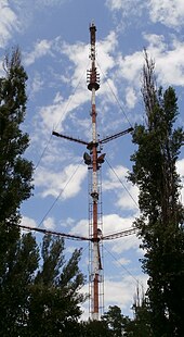
Kryvyi Rih TV broadcasting mast
The Krywyj Rih television transmission mast is a 185 m high guyed tubular steel mast of the type 30107 KM , which was built in 1960 and is equipped with cross members on two levels with three cross members leading from the mast structure to the guy ropes. On these cross beams there is a walkway with a railing and some smaller antennas.
BAK Krivoy Rog
In 1985, about 55 km northwest of the city of Krywyj Rih, near Dolynska in the Kirowohrad Oblast , the BAK Krivoy Rog , one of the world's largest industrial construction projects at the time, began. The mining and ore mining and processing Krivoy Rog (BAK / ГОК) should from the Soviet Union and a number of socialist countries in the CMEA be built jointly, so that construction crews from Czechoslovakia , Romania , the German Democratic Republic (u. A. VEB Mansfeld-Kombinat "Wilhelm Pieck" , VEB BMK Coal and Energy ) and the People's Republic of Bulgaria collaborated. The aim of the project was to build a large-scale plant in which iron oxide ore with an iron content of around 40 percent was to be processed using a new technology. The planned final capacity of the plant was 33.7 million tons per year. After the political change, the German construction crews finished their work in 1992 when two thirds of the construction had been completed. Its full completion was not achieved.
Transfiguration Cathedral
The Transfiguration Cathedral is a 43-meter-high cathedral in the style of the Ukrainian Baroque , consecrated in 2003 . It is the episcopal seat of the Bishop of the Diocese of Krivoy Rog-Nikopol of the Ukrainian Orthodox Church of the Moscow Patriarchate .
Town twinning
-
 Nizhny Tagil , Russia
 -
 Handan , People's Republic of China
sons and daughters of the town
- Helena Makowska (1893–1964), Polish actress
- Hennadij Udovenko (1931–2013), politician and diplomat
- Tamara Kasanzewa (* 1934), geologist
- Walentyna Shevchenko (1935–2020), politician
- Jurij Wilkul (* 1949), university rector and mayor of Krywyj Rih
- Petro Dyminskyj (* 1954), entrepreneur and sports official
- Serhij Fessenko (* 1959), swimmer
- Oleksandr Popov (* 1960), politician
- Jaroslaw Schramko (* 1963), University Rector
- Wladimir Malachow (* 1968), Austrian dancer and artistic director
- Aljona Babak (* 1969), Minister for Local and Territorial Development
- Ivan Bakanow (* 1974), filmmaker and head of the secret service
- Slava Seidel (* 1974), painter and draftsman
- Oleksandr Wilkul (* 1974), politician
- Volodymyr Selenskyj (* 1978), actor and filmmaker, President of Ukraine
- Valeria Bondarenko (* 1982), tennis player
- Witali Malykin (* 1982), chess player
- Aljona Bondarenko (* 1984), tennis player
- Daryna Apanashchenko (* 1986), football player
- Kateryna Bondarenko (* 1986), tennis player
- Iwan Senaj (* 1987), boxer
- Jewhen Chytrow (* 1988), boxer
Rajon
Kryvyi Rih Raion is administered from Kryvyi Rih, which, however, is not part of it. Apart from the south, the Rajon surrounds the entire city area and has an area of 1347.24 km². With its 44,972 inhabitants, 2012 results in a population density of 33 inhabitants per km².
Web links
- Official site (Ukrainian)
- Map (russian)
- The Herald Krivbass: News from the region (Ukrainian)
Individual evidence
- ↑ Demography of Ukrainian Cities. pop-stat.mashke.org.
- ↑ Нові вулиці Кривого Рогу - затверджено! veskr.com.ua (Ukrainian).
- ↑ Description of the reservoir. 1775.dp.ua (Russian)
- ↑ a b Перші поселення (1734-1775). (No longer available online.) City of Kryvyi Rih, archived from the original on May 30, 2015 ; Retrieved November 1, 2014 (Ukrainian). Info: The archive link was inserted automatically and has not yet been checked. Please check the original and archive link according to the instructions and then remove this notice.
- ↑ a b c d e f g h i Заснування поштової станції, перші геологічні досліди (1775 - 1799). (No longer available online.) In: City of Kryvyi Rih. Archived from the original on November 29, 2014 ; Retrieved November 22, 2014 (Ukrainian). Info: The archive link was inserted automatically and has not yet been checked. Please check the original and archive link according to the instructions and then remove this notice.
- ↑ a b c d e f g Військове поселення, село, містечко. Систематичні геологічні розвідки ( 1802-1880 ). (No longer available online.) City of Kryvyi Rih, archived from the original on November 29, 2014 ; Retrieved November 22, 2014 (Ukrainian). Info: The archive link was inserted automatically and has not yet been checked. Please check the original and archive link according to the instructions and then remove this notice.
- ↑ Crimes of the Wehrmacht - Dimensions of the War of Extermination. verbrechen-der-wehrmacht.de, accessed October 7, 2015 (PDF file).
- ↑ POW camp. Moosburg online.
- ↑ У Кривому Розі готують Майдан через фальсифікації. Pravda, November 17, 2015, accessed December 25, 2015. (Ukrainian)
- ↑ Кривий Ріг: Силовики намагалися розігнати мітинг під міськвиконкомом. German Krywyj Rih: Security forces tried to break up the rally against the mayoral election ( memento of the original from November 21, 2015 in the Internet Archive ) Info: The archive link was automatically inserted and not yet checked. Please check the original and archive link according to the instructions and then remove this notice. hromadske.tv , November 17, 2015, accessed December 25, 2015. (Ukrainian)
- ↑ Рада призначила дострокові вибори в Кривому Розі на 27 березня. dt. The council ordered early elections in Krywyj Rih for March 27th. Pravda, December 23, 2015, accessed December 25, 2015. (Ukrainian)
- ↑ Demography of Ukrainian cities on pop-stat.mashke.org
- ↑ 1959 Census of the USSR on webgeo.ru
- ↑ 1970 Census of the USSR on webgeo.ru
- ↑ Census of the USSR 1979 on webgeo.ru
- ↑ Climate data on meteoprog.ua
- ↑ Климат Кривого Рога. pogodaklimat.ru, accessed on October 22, 2014 (climate data from Kryvyi Rih).
- ^ BAK Krivoy Rog.


