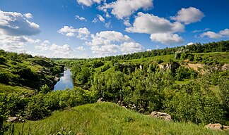
Dnieper highlands
| Dnieper highlands | |
|---|---|
| Highest peak | at Chmilnyk ( 341.8 m nm ) |
| part of | Eastern European level |
|
The Hirskyj Tikytsch in the Dnieper highlands |
|
The Dnepr highlands ( Ukrainian Придніпровська височина Prydniprowska vyssochyna ) is a highland up to 341.8 m high in the southeast of the Eastern European Plain in the center of Ukraine .
The Dnepr highlands are the extension of the Podolian Plate to the east between the central reaches of the Dnieper and the southern Bug and the source region of numerous rivers such as Basawluk , Hirskyj Tikytsch , Inhul , Inhulez , Mokra Sura , Ros , Saksahan , Synjucha , Tschornyj Taschlyk and Tjasmyn . In the east and south-east the highlands are on average 150 m to 180 m high, in the north-west 220 m to 240 m . In the northwest, it reaches its highest point at 341.8 m ( ⊙ ) about three kilometers northwest of the village of Koschuchiw (Кожухів) south of Chmilnyk .
The Dnepr highlands are located in these six oblasts: Dnipropetrovsk , Kiev , Kirovohrad , Zhytomyr , Cherkassy and Vinnytsia . In the interior or on the outskirts there are, among others, the following places: Berdychiv , Bila Tserkva , Kropywnyzkyj , Krywyj Rih , Zhytomyr , Uman and Vinnytsia ; the latter is located in the transition area to the Podolische Platte on the southern bow. In the north the Dnieper highlands are part of the forest steppe zone and in the south part of the steppe zone. Geologically, the landscape is part of the Ukrainian Shield and is rich in mineral resources such as iron ore in the Krywbass and manganese .
Individual evidence
- ↑ a b Topographical map (1: 100.000, Bl. M-35-92, Ed. 1977), part of the Dnepr highlands (about middle right to middle above) and a. with Chmilnyk (in the middle, top right) on the Southern Bug , Koschuchow (a little below) and Letychev (bottom left) also on the Southern Bug with the Podolian plate there , on mapm35.narod.ru (with heights above sea level )
literature
- Small mining lexicon in 3 volumes , Ed. B. S. Bilezkyj, Donetsk, 2004, ISBN 966-7804-14-3
Coordinates: 49 ° 7 ' N , 30 ° 37' E

