Tyasmyn
|
Tjasmyn Тясмин, Тя́смин (Tjasmin) |
||
|
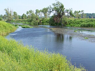
Tjasmyn at Smila |
||
| Data | ||
| location | Oblast Kirovohrad , Cherkasy Oblast ( Ukraine ) | |
| River system | Dnepr | |
| Drain over | Dnepr → Black Sea | |
| source | Central Dnieper Highlands 48 ° 59 ′ 57 ″ N , 32 ° 27 ′ 29 ″ E |
|
| muzzle | in the Dnepr dammed up to the Kremenchuk reservoir coordinates: 49 ° 3 '56 " N , 32 ° 48' 13" E 49 ° 3 '56 " N , 32 ° 48' 13" E |
|
| Mouth height |
81 m
|
|
| length | 161 km | |
| Catchment area | 4540 km² | |
| Drainage location: 11 km above the mouth |
MQ |
6.6 m³ / s |
| Left tributaries | Hnylyj Taschlyk , Sribljanka , Irdyn | |
| Right tributaries | Irklij , Tschutka | |
| Medium-sized cities | Smila | |
| Small towns | Tschyhyryn , Kamjanka | |
| Communities | Chazky | |
The Tjasmyn ( Ukrainian Тясмин , Russian Тя́смин / Tjasmin ) is a right tributary of the Dnepr with a length of 161 km and a catchment area of 4540 km² (according to other sources 4570 km²). It rises in the north of the central part of the Dnieper highlands in the central Ukrainian Oblast Kirovohrad . From there it flows through the Cherkassy Oblast , where it finally flows into the Dnepr, which is dammed into the Kremenchuk reservoir . The river forms a river knee in its middle course , in which it changes its course by 180 °. As a result, the source and mouth are only 33 km apart. The width of the river valley varies between one and four kilometers, while the river reaches a width of up to 20 m. The runoff regime is nival .
In the lower reaches near the village of Subotiv there are important sites of the Belogrudovka / Cernoles culture . For archaeologists, these represent a key point for the Late Bronze Age and its change to the Early Iron Age .
Larger towns on the Tyasmyn River are Kamjanka , Smila and Tschyhyryn . The city of Novoheorhijiwsk was located at the mouth of the Dnieper until the reservoir was built .

