Ros (Dnepr)
|
Ros Рось |
||
|
Catchment area of the Dnepr and course of the Ros ( Рось ) |
||
| Data | ||
| location | Oblast Vinnytsia , Kiev Oblast , Cherkasy Oblast ( Ukraine ) | |
| River system | Dnepr | |
| Drain over | Dnepr → Black Sea | |
| source | in the Dnieper highlands ( Prydniprowska vyssotschyna ) 49 ° 23 ′ 20 ″ N , 29 ° 2 ′ 15 ″ E |
|
| muzzle | in the Dnepr dammed up to the Kremenchuk reservoir coordinates: 49 ° 38 '11 " N , 31 ° 38' 10" E 49 ° 38 '11 " N , 31 ° 38' 10" E
|
|
| length | 346 km | |
| Catchment area | 12,600 km² | |
| Outflow location: 65 km above the mouth |
MQ |
22.5 m³ / s |
| Left tributaries | Rostavytsja , Kamjanka , Rossava | |
| Right tributaries | Roska | |
| Big cities | Bila Tserkva | |
| Small towns | Korsun-Shevchenkivskyi , Stebliw , Bohuslav , Rokytne , Volodarka , Pohrebyschtsche | |
| Communities | Shkariwka , Sachniwka | |
|
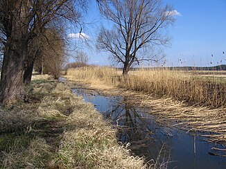
The Ros at Sukholesi |
||
The Ros ( Ukrainian and Russian Рось ) is a 346 km long right tributary of the Dnieper in northern Ukraine . It rises in the Dnieper highlands and runs through the Vinnytsia , Kiev and Cherkassy oblasts . Its main tributaries are the Roska on the right bank, the Rostawyzja , Kamjanka and Rossava on the left bank . The towns of Bila Tserkva , Bohuslav and Korsun-Shevchenkivskyi are located along the course of the river .
According to one version, the river gave its name to the ethnonyms Russians and Russia (Russian: Rossija ).
Web links
Commons : Ros - collection of images, videos and audio files
Individual evidence
- ↑ a b c Article Ros in the Great Soviet Encyclopedia (BSE) , 3rd edition 1969–1978 (Russian)


