Handan
| Basic data | ||
|---|---|---|
| Greater Region: | North china | |
| Province : | Hebei | |
| Status: | district-free city | |
| Subdivision: | 4 city districts, 14 districts, 1 urban district | |
| Residents : | 9,492,800 (2016) | |
| Area : | 12,087 km² | |
|
|
||

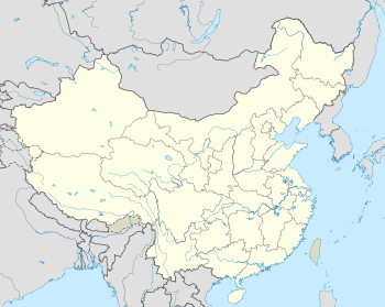
Handan ( Chinese 邯鄲市 / 邯郸市 , pinyin Handan shì ) is a Chinese prefecture-level city in the southern province of Hebei . Handan has a total of approx. 9.17 million inhabitants, of which 919,295 (2010 census) live in the urban settlement. During the Warring States Period in the 4th and 3rd centuries BC It was the capital of the empire Zhao (趙). There is a steel industry in the city, which is favored by the nearby coal mining industry. The mining company Handan Iron and Steel has its headquarters in Handan.
Handan is the bishop's seat of the Roman Catholic diocese of Taming .
Geography and administrative structure
The administrative area of the city of Handan has an area of 12,087 km², 450 km² of which is inner city area. The city is made up of four urban districts, 14 districts and one urban district:
- Congtai district (丛台 区 / 叢台 區), 28 km², approx. 330,000 inhabitants (2003);
- Hanshan district (邯山区 / 邯山區), 32 km², approx. 290,000 inhabitants (2003);
- Fuxing district (复兴 区 / 復興 區), 37 km², approx. 250,000 inhabitants (2003);
- District Fengfeng Mining District (峰峰矿区/峰峰礦區), 353 square kilometers, about 500,000 inhabitants (2003);
- Handan district (邯郸 县 / 邯鄲 縣), 522 km², approx. 380,000 inhabitants (2003);
- Linzhang district (临漳县 / 臨漳縣), 744 km², approx. 580,000 inhabitants (2003);
- Cheng'an County (成 安县 / 成 安縣), 485 km², approx. 360,000 inhabitants (2003);
- Daming district (大名 县 / 大名 縣), 1,052 km², approx. 740,000 inhabitants (2003);
- She district (涉县 / 涉縣), 1,509 km², approx. 380,000 inhabitants (2003);
- District Ci (磁县 / 磁縣), 1,035 km², approx. 630,000 inhabitants (2003);
- Feixiang district (肥乡县 / 肥鄉縣), 496 km², approx. 310,000 inhabitants (2003);
- Yongnian district (永年 县 / 永年 縣), 898 km², approx. 830,000 inhabitants (2003);
- Qiu district (邱县 / 邱縣), 448 km², approx. 200,000 inhabitants (2003);
- Jize district (鸡泽县 / 雞澤縣), 337 km², approx. 250,000 inhabitants (2003);
- Guangping County (广 平县 / 廣 平縣), 320 km², approx. 250,000 inhabitants (2003);
- Guantao County (馆陶 县 / 館陶 縣), 456 km², approx. 290,000 inhabitants (2003);
- District Wei (魏县 / 魏縣), 862 km², approx. 800,000 inhabitants (2003);
- Quzhou district (曲周 县 / 曲周 縣), 667 km², approx. 400,000 inhabitants (2003);
- City of Wu'an (武安市 / 武安市), 1,806 km², approx. 710,000 inhabitants (2003).
Capital of the ancient Zhao state
The site of the capital of the state Handan Zhao ( Zhao Handan Gucheng赵邯郸故城) from the Warring States Period is since 1961 on the list of monuments of the People's Republic of China (1-149).
Web links
- Ancient Handan City of Zhao State (English)
Coordinates: 36 ° 36 ' N , 114 ° 29' E


