Qaraoun reservoir
| Qaraoun Reservoir بحيرة القرعون (Arabic) |
|||
|---|---|---|---|
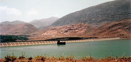
| The Qaraoun lake behind the El Wauroun dam. | |||
|
|||
|
|
|||
| Coordinates | 33 ° 34 '12 " N , 35 ° 41' 51" E | ||
| Data on the structure | |||
| Lock type: | dam | ||
| Crown length: | 240 m | ||
| Data on the reservoir | |||
| Water surface | 11.9 km² | ||
| Storage space | 220 × 10 6 m³ | ||
| Catchment area | 1 600 km² | ||
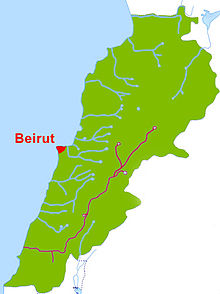
The Qara'un Reservoir (also: Qaraoun Reservoir , Arabic بحيرة القرعون, DMG Buḥayrat al-Qara'ūn ) is a reservoir in the south of the Bekaa plain in Lebanon . It was created in 1959 in the village of Qaraoun through the construction of the El-Qaroun Dam (El Wauroun Dam). This is the largest dam in Lebanon with a height of 61 m, designed as a cement-clad stone dam, on the middle course of the Litani . The reservoir is used to generate electricity (190 MW), for domestic water supply and to irrigate 27,500 hectares of land.
The lake has become an important habitat for the 20,000 migratory birds that stop there every year.
geography
The Litani, one of 40 main rivers and the longest river in Lebanon with a length of 170 km, has its source near the ancient city of Baalbek . The source is hardly recognizable today because so much water is pumped out. In the area of the "Upper Litani" the reservoir was built at 800 m above sea level in the Bekaa plain. Around the plain rise the Lebanon Mountains in the west and the Anti-Lebanon in the east. The Bekaa-Eben is a continuation of the Jordan Rift . The catchment area of the reservoir covers approx. 1,600 km², ie approx. 15.3% of the area of Lebanon. The surrounding lands are used for agriculture. Above all, cereals and olives are grown, as well as sheep and goat grazing. There are also a number of orchards on the steeper slopes to the west of the lake.
El-Qaroun dam
The El Qaroun Dam (El Wauroun Dam) was built about 70 km south of Baalbek . Planning for this began as early as 1964. The village of Qaraoun had to cede 760 hectares of land on which the dam was built. It has a concrete shell and a quarry stone core, is 61 m high and 801 m long at the top, with a total of 1,090 m long. the reservoir has a capacity of 220 million m³ with a maximum filling height of 57 m. The highest flood level (HFL) is 862 m, the largest surface area is 12.6 km², on average 1190 ha. The average water level for electricity generation is 835 m, with the lowest level at which this is possible at 827 m lies. The dam area upstream is 47,000 m², the thickness of the cement layer varies between 50 cm at the bottom and 30 cm at the top. The capacity is designed for a flood discharge of up to 450 million m³.
Water resources
The Litani has an annual pouring of approx. 1,280 million. m³. 60% of this is required to keep the aquifers watered and to compensate for evaporation ( evapotranspiration ). Of the usable 500 mio. m³ / year are 80 mio. m³ / year used for irrigation and water supply before the water reaches the dam. Therefore, in the end, an average of only 420 million. m³ usable at the dam. In dry years this amount can reach 320 million. m³ (as in the years 1972–73) decrease. Therefore, up to 320 million. m³ used. The water for energy generation is diverted through a series of tunnels and reservoirs, whereby 600 GWh (190 MW / year) are generated at three power plants. The power plants are located at Markaba , Awali and Jun. The original plan from the 1950s was to use a much larger head of 800 m between the dam and the Mediterranean Sea . The outlet of the river after the last power station in this series is now 30 km north of the original outflow. In addition, 30 mio. m³ / year derived from the Markaba Power Station for the Kassmieh Irrigation Project .
reservoir
The Qaraoun reservoir with an area of 11.9 km² is the largest artificial lake in Lebanon and has a capacity of 220 million. m³ and a storage capacity of 160 mio m³. Energy production covers 7% –10% of energy consumption in Lebanon. The water is piped to southern Lebanon and used for domestic water supplies as well as for irrigation projects, 30 million of which. m³ in Bekaa and 20 mio. m³ in the domestic water supply in southern Lebanon. In addition, the dam is used for flood protection and prevents the watering of 1500 hectares of land in certain karst areas .
Between 1999 and 2000, water samples were taken at various points by the Ministry of the Environment and the Litani River Authority in order to develop an environmental management plan. Until then, untreated wastewater from Baalbek, Houch el Rafqa, Qaa er Rim, Zahle, Chtoura, Qabb Elias, Bar Elias, Joub Jannine and Qaraoun ran directly into the Litani and its tributaries. Industrial wastewater was also discharged. An enormous biochemical oxygen demand could be determined (79 mg / L) and the nitrate values (1.7 mg / L) were very high. In 2015 a concept for the Lake Qaraoun Pollution Prevention Project was published.
The vegetation around the lake consists of forest areas, orchards and bushland. There are hardly any aquatic plants in the lake itself. When the bank dries up, a steppe-like landscape develops, offering ideal conditions for larks and lapwing .
The bird fauna is particularly remarkable because 20,000 specimens of birds of prey , storks and pelicans stop here when they migrate. Bog ducks ( Aythya nyroca ), steppe harrier ( Circus macrourus ), greater spotted eagle ( Aquila clanga ), eastern imperial eagle ( Aquila heliaca ) and steppe lapwing ( Vanellus gregarius ) are among the protected bird species on the Red List of Threatened Species from 2008 that occur here.
geology
Geologically, the area around the lake belongs to limestone , calcareous marl and alluvial formations, in which karst phenomena also occur. The marl in the area of the reservoir has a low permeability.
Planning
There are considerations in the Qaraoun Lake-Marj et Taouil Project to use the lake water for a pumped storage power plant and to store it on a dam with a height of 50.6 m at 1679 m above sea level. This is intended to improve energy production.
climate
The climate in the catchment area of the reservoir is continental with 90% of the rainfall between November and April. January has the greatest chance of precipitation. Snow falls at altitudes above 1500 m. The amount of rain in the Bekaa plain is 1,500 mm on average in the mountain regions of the Upper Litani and in the south on the coast at less than 700 mm. In the catchment area of the reservoir in the narrower sense, the amount of rain averages 800 mm.
archeology
The archaeological site of Ain Jaouze is located above the Qaraoun reservoir at the foot of the Jebel Baruk, west of the road from Chtaura to Jezzine . The Jesuit and archaeologist Auguste Bergy discovered flint tools there that are comparable to the tools of the later Neolithic Byblos .
Attractions
A number of restaurants and hotels have sprung up in the west of the lake and are popular excursion destinations in spring and early summer. There are also a number of boats for day trippers and anglers on the lake. Migratory birds are also hunted in winter.
Individual evidence
- ↑ a b Qaraoun Village . aub.edu.lb. Archived from the original on September 17, 2007. Info: The archive link was automatically inserted and has not yet been checked. Please check the original and archive link according to the instructions and then remove this notice. Retrieved April 23, 2011.
- ↑ a b c d e f Lake Qaraoun . Birdlife.org. Retrieved April 24, 2011.
- ↑ a b c d e Chapter 2. Assessing Lebanon's Water Balance . International Development Research Center (idrc). Archived from the original on March 12, 2010. Info: The archive link was inserted automatically and has not yet been checked. Please check the original and archive link according to the instructions and then remove this notice. Retrieved April 25, 2011.
- ↑ a b Lebanon State of the Environment Report (pdf) Ministry of Environment, Government of Lebanon. Archived from the original on July 21, 2011. Info: The archive link was inserted automatically and has not yet been checked. Please check the original and archive link according to the instructions and then remove this notice. Retrieved April 25, 2011.
- ↑ a b Lebanon . Aquasta: Fao.org. Retrieved April 26, 2011.
- ↑ a b C. A. Brebbia, KL Katsifarakis: River Basin Management IV . WIT Press, 2007, ISBN 978-1-84564-075-0 , pp. 484– (accessed April 26, 2011).
- ↑ a b International Commission on Large Dams; International Association for Hydraulic Research; International Commission on Irrigation and Drainage: International journal on hydropower & dams . Aqua-Media International, 2008, pp. 76-77 (accessed April 24, 2011).
- ^ A b Introducing Pumped Storage in Lebanon: Towards a Prospective National Master Plan (pdf) Littani River Authority. Retrieved April 24, 2011.
- ↑ http://www.databank.com.lb/docs/Lake%20Qaraoun%20Pollution%20Prevention%20Project.pdf
- ^ International Commission on Large Dams; International Association for Hydraulic Research; International Commission on Irrigation and Drainage: International journal on hydropower & dams . Aqua-Media International, 2008, p. 77– (accessed April 26, 2011).
- ↑ Université Saint-Joseph (Beirut, Lebanon): Mélanges de l'Université Saint-Joseph . Impr. Catholique, 1966 (Retrieved May 1, 2011).
- ↑ AMT Moore: The Neolithic of the Levant . Oxford University, Unpublished Ph.D. Thesis, 1978, pp. 436-442.


