Röderkirchhof
|
Röderkirchhof
Schleid municipality
Coordinates: 50 ° 41 ′ 9 ″ N , 9 ° 58 ′ 25 ″ E
|
||
|---|---|---|
| Height : | 330 m above sea level NN | |
| Residents : | 1 (Sep 21, 2012) | |
| Postal code : | 36419 | |
| Area code : | 036967 | |
|
Location of Röderkirchhof in Thuringia |
||
|
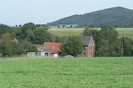
View from the south (2012)
|
||
The Röderkirchhof is a single farm in the municipality of Schleid in the Wartburg district in Thuringia . The courtyard belonging to the Motzlar district is currently (2012) inhabited by a man.
location
The Röderkirchhof farmstead is located about 500 m from Motzlar on the Hessian-Thuringian border in the Rhön biosphere reserve . The geographic height of the place is 330 m above sea level. NN .
history
The place name refers to a property (churchyard) belonging to the rectory in Motzlar. The residents were schooled and parish in Motzlar.
Web links
Commons : Röderkirchhof - Collection of images, videos and audio files
Individual evidence
- ↑ own research
- ↑ Official topographic maps of Thuringia 1: 10,000. Wartburgkreis, district of Gotha, district-free city of Eisenach . In: Thuringian Land Survey Office (Hrsg.): CD-ROM series Top10 . CD 2. Erfurt 1999.
- ^ Adelbert Schröter Land on the Road. The history of the Catholic parishes in the Thuringian Rhön.

