Unterrothhof
|
Unterrothhof
Schleid municipality
Coordinates: 50 ° 41 ′ 19 ″ N , 9 ° 58 ′ 46 ″ E
|
||
|---|---|---|
| Height : | 347 m above sea level NN | |
| Postal code : | 36419 | |
| Area code : | 036967 | |
|
Location of Unterrothhof in Thuringia |
||
|
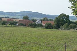
Partial view from the north (2012)
|
||
The Unterrothhof is a homestead owned by Schleid in the Wartburg district in Thuringia .
location
The Unterrothhof is located between Schleid and Motzlar east of the federal highway 278 . With a connecting route it is recorded in terms of traffic. It is located in the Rhön Biosphere Reserve . The geographic height of the place is 347 m above sea level. NN .
history
The Unterrothhof was first mentioned in a document on October 4th, 1309. Currently (2012) 13 people live in the Rothshöfe. The place name refers to a group of farmsteads that were probably built at the same time in the vicinity (3 km as the crow flies) of the Fulda district castle Rockenstuhl and this castle served as farmyards.
Web links
Commons : Unterrothhof - Collection of images, videos and audio files
Individual evidence
- ↑ Official topographic maps of Thuringia 1: 10,000. Wartburgkreis, district of Gotha, district-free city of Eisenach . In: Thuringian Land Survey Office (Hrsg.): CD-ROM series Top10 . CD 2. Erfurt 1999.
- ^ Wolfgang Kahl : First mention of Thuringian towns and villages. A manual. Rockstuhl Verlag, Bad Langensalza, 2010, ISBN 978-3-86777-202-0 , p. 295.

