Crane gaps
|
Crane gaps
Schleid municipality
Coordinates: 50 ° 41 ′ 58 ″ N , 9 ° 59 ′ 27 ″ E
|
||
|---|---|---|
| Height : | 356 m above sea level NN | |
| Residents : | 273 (2012) | |
| Incorporation : | June 30, 1994 | |
| Postal code : | 36419 | |
| Area code : | 036967 | |
|
Location of Kranlucken in Thuringia |
||
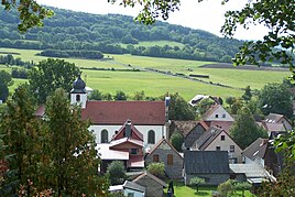
Kranlucken is a district of Schleid in the Wartburg district in Thuringia .
location
Kranlucken is located in the area surrounding the Hessian-Thuringian border in the foreland of the Thuringian Rhön biosphere reserve in an area sloping south and bordered by forest to the north. The Roßberg with 693.6 meters above sea level is the highest mountain near Schleid. The village is covered by traffic from the county road 93. Shortly before Schleid you reach the federal road 278 . The geographic height of the place is 356 m above sea level. NN .
history
Kranlucken was first mentioned in a document on September 28, 1197. In 2012, 273 inhabitants lived in the district that was and is agricultural. For centuries it belonged to the Geisa / Rockenstuhl Office of Fulda .
In 1994 the villages of Kranlucken, Motzlar , Zitters and Schleid merged to form the unified municipality Schleid. During the GDR era, the farmers worked together in the LPG type III "Karl Liebknecht" based in Bremen for plant production and the LPG type III "Vorderrhön" in Geisa in animal production and operated cattle fattening and milk production.
After the political change , they reoriented themselves. The population of the area was now freed from the border problems of the post-war period .
Culture and sights
- The Catholic parish church "Heiligste Dreifaltigkeit" (Holy Trinity) with rich baroque facade decorations was consecrated in 1756 and restored in 1796 after a fire.
- The rectory was originally built in 1792 in Petersberg near Fulda as a hunting lodge.
- The cemetery with a small chapel and the memorial for the fallen on the southern slope also offers a wonderful view of the upper Ulstertal.
- The home parlor at the church is open 24 hours. Inside, a model of the terrain of the Kohlbachtal was set up, photos and reports about the Kranluck clubs were attached.
- A mobile on Motzlaer Weg rotates powered by a water wheel and commemorates the local anniversary in 2007.
- The old Kohlbach bridge by the church is a listed natural stone bridge.
- A memorial stone with the Kranluck coat of arms reminds of the flood disaster of 1913 by the bridge, it is located directly at the church
- Several wells stand out in the townscape, they were also set up in connection with the town's anniversary.
- There are several wayside shrines in and around the village. At Hof Hochrain there is the baroque picture stone, which was mounted on a stone column until 1912 and has a small wrought-iron cross on the top. The wayside shrine shows the Holy Trinity on the east side, the Holy Family on the west side, and Mary with the child and John of Nepomuk on the narrow sides .
- Many half-timbered houses shape the intact townscape
Well-known sons and daughters
- Hermann Fischer (born March 15, 1928)
Web links
Individual evidence
- ↑ Official topographic maps of Thuringia 1: 10,000. Wartburgkreis, district of Gotha, district-free city of Eisenach . In: Thuringian Land Survey Office (Hrsg.): CD-ROM series Top10 . CD 2. Erfurt 1999.
- ^ Wolfgang Kahl : First mention of Thuringian towns and villages. A manual. Rockstuhl Verlag, Bad Langensalza, 2010, ISBN 978-3-86777-202-0 , p. 153
- ^ Thuringian ordinance on the dissolution and amalgamation of the municipalities of Kranlucken, Motzlar, Schleid and Zitters of March 1, 1994 (GVBl. P. 308)
- ↑ Bruno Leister: On the history of the Kohlbachhof in the Geisa office. Meiningen 1998, p. 11f.


