Rader Island
| Rader Island | ||
|---|---|---|
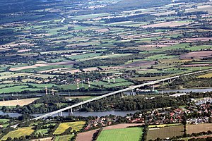
| Rader Insel and Rader Hochbrücke, looking south-east | ||
| Waters | Kiel Canal | |
| Geographical location | 54 ° 20 '5 " N , 9 ° 43' 36" E | |
|
|
||
| length | 2.44 km | |
| width | 625 m | |
| surface | 1 km² | |
| main place | Inselhof | |
The Rader Island is an artificial island in the North Sea-Baltic Canal east of Rendsburg.
location
The island is located in the district of Rendsburg-Eckernförde , Schleswig-Holstein . It extends from the eponymous Rade b. Rendsburg to Schacht-Audorf and Borgstedt in the southwest. The larger northeast part of the island belongs to the municipality of Rade, the smaller southwest part to the neighboring municipality of Schacht-Audorf. A small part in the extreme southwest belongs to Borgstedt.
history
The island is about 2.5 kilometers long and up to 625 meters wide. It was created when the canal was straightened at Borgstedt between 1912 and 1914, between the previous canal bed in Borgstedter Enge and the new canal bed built further south.
In 1937 a bridge was built from Borgstedt to Rader Island. Until then, the island could only be reached via the railway ferry on the Osterrönfeld – Rader Insel railway line .
Since 1972, at a height of 49 m, the federal motorway 7 has crossed the Kiel Canal , the Rader Island and the Borgstedter Enge on the Rader Hochbrücke .
Web links
Individual evidence
- ↑ Borgstedt community. (No longer available online.) Archived from the original on December 26, 2012 ; Retrieved December 29, 2011 . Info: The archive link was inserted automatically and has not yet been checked. Please check the original and archive link according to the instructions and then remove this notice.

