
Raischibe
| Raischibe | ||
|---|---|---|
 Raischibe with Seez viaduct of Walenstadt from |
||
| height | 658 m above sea level M. | |
| location | Canton of St. Gallen , Switzerland | |
| Dominance | 0.8 km → Aulinachopf | |
| Notch height | 119 m ↓ Raischibli | |
| Coordinates | 741 522 / 219753 | |
|
||

The Raischibe is a 658 m above sea level. M. high elevation at the eastern end of the Walensee in the Swiss canton of St. Gallen .
An approximately 800 m long tunnel of the A3 motorway , also known as the Walensee motorway , runs through the hill . The Ziegelbrücke-Chur railway line crosses under the western foothills of the Raischibe in the Bommerstein tunnel.

Raischibe and new Bommerstein tunnel fourths of
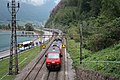
Main road and railway line between Walensee and Raischibe
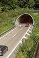
Raischibe motorway tunnel, view towards Chur
_(44527202241).jpg)
.jpg)

The wooded mountain stands on the left bank of the Walensee and is flanked in the north by the aforementioned railway line and Hauptstrasse 3 , in the northeast by the Seez and in the southeast and south by the 380 kV line Sils-Fällanden .
As Reischiben formation in which is lithostratigraphy a moderate, gray anwitternde sequence of schräggeschichtetem, sandy lime and Spatkalk with gray or red Echinodermenbrekzie , as well as minor marl referred to as at the Raischibe as type locality comes to light.
There is an archaeological site on the Raischibe.
Web links
Individual evidence
- ↑ Jan Willem Menkveld: The geological structure of the Helveticum central Switzerland. Dissertation University of Bern, 1995.
- ↑ Inventory sheet 40.039 Archaeological sites of the Canton of St. Gallen worth protecting