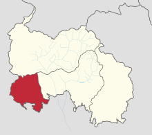
Snaur Raion
The Rajon Snaur ( Georgian რაიონი ზნაურის , Snauris Raioni; Ossetian район Знауыры , Snauyry rayon, Russian район Знаурский , Snaurski rayon ), with an area of 404 sq km, the smallest of the four Rajone within the administrative structure of only a few countries recognized as independent Republic of South Ossetia .
The area is not under the control of the Georgian central government. According to the Georgian administrative structure, it forms the northernmost part of Kareli Municipality of the Inner Kartlien region .
The administrative seat and namesake is the urban-type Snaur settlement . The Rajon has 4531 inhabitants (2015).
geography
In north-south direction the Rajon extends to 26 km, in west-east direction to 24 km. There are mineral springs near the villages of Nagutni and Dsadina .
history
The Rajon was designated as part of the South Ossetian Autonomous Region as early as the 1930s . In 1939 it had 18,782 inhabitants. By 1989, their number fell continuously to 10,195.
After the conflict over South Ossetia began in 1991, most of the area was under South Ossetian control, only a part with four villages around the village of Auneu (Georgian Awnewi ) with a total of 1591 inhabitants (2002) was under Georgian control. According to the Russian news agency Regnum, Georgia cut off this part of the South Ossetian-controlled part in March 2008 in order to force the Ossetian farmers to accept Georgian citizenship. As a result of the Caucasus War , the entire Raion has been controlled by South Ossetia since August 2008. As a result of the conflict with the destruction of many villages, the number of inhabitants of the Rajon fell again by more than half compared to 1989.
- Population development

Note: census data
Individual evidence
- ^ Press conference of the head of the South Ossetian statistical agency . Report from the South Ossetian Res news agency dated August 11, 2016, accessed on April 27, 2017.
- ^ South Ossetia: The Georgian side blocks Ossetian villages near Regnum, March 19, 2008. Retrieved April 27, 2017.
Coordinates: 42 ° 15 ' N , 43 ° 45' E
