Rajpipla (State)
| Rajpipla | |||||
| 1340-1948 | |||||
|
|||||
| Capital | Rajpipla | ||||
| Form of government | Princely state (13 shot salute) | ||||
| surface | 3919 km² | ||||
| population | 237,000 (1941) | ||||
| founding | 1340 | ||||
| resolution | June 10, 1948 | ||||
| State religion: Hinduism Dynasty: Gohil |
|||||
| Painting by Manvendra Singh Gohil | |||||
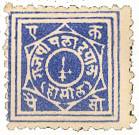
| Postage stamp from Rajpipla (1880) | |||||
Rajpipla was a princely state of British India in the Rewa Kantha region in what is now the state of Gujarat on the Narmada ( Narbada ) above its mouth into the Arabian Sea at Bharuch ( Broach ). Its capital was the place Rajpipla . The Rajput principality was subjected to the Mughal Empire by Akbar I. At the end of the 18th century, the Marathas under the Gaekwar of Baroda conquered the country and completely occupied it in 1815. In 1821 Rajpipla became a British protectorate (until 1947) and was under direct British administration from 1887–1897. The Maharana ( Maharaja ) was annexed to India on June 10, 1948 , and Rajpipla became part of the state of Bombay . It has belonged to the state of Gujarat since 1960.
Rajpipla had a state post with its own stamps from 1880–1886 . In 1941 the principality had an area of 3919 km² and 237,000 inhabitants.
literature
- Andreas Birken : Philatelic Atlas of British India. CD-ROM. Birken, Hamburg 2004.
- George B. Malleson: An historical sketch of the native states of India. Longmans, Green & Co., London 1875, ( digitized version ).
- Rājpīpla. In: The Imperial Gazetteer of India. Volume 21: Pushkar to Salween. New Edition. Clarendon Press, Oxford 1908, pp. 79-25 .
- Joseph E. Schwartzberg (Ed.): A historical atlas of South Asia (= Association for Asian Studies. Reference Series. 2). 2nd impression, with additional material. Oxford University Press, New York NY et al. 1992, ISBN 0-19-506869-6 .


