Ramspau (Regenstauf)
|
Ramspau
Regenstauf market
Coordinates: 49 ° 9 ′ 19 ″ N , 12 ° 8 ′ 31 ″ E
|
|
|---|---|
| Incorporation : | January 1, 1978 |
| Postal code : | 93128 |
| Area code : | 09402 |
|
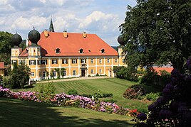
View of Ramspau Castle and its garden
|
|
Ramspau is a parish village in the market town of Regenstauf in the Regensburg district in Bavaria . Ramspau was the seat of the municipality of the same name until 1978 .
history
The castle Ramspau was probably built before the 13th century. In 1312 a knight "Weichser de Ranspaur" is attested for the first time. Around 1694 the place came into the possession of Count Johann Siegmund Anton Franz von Reisach (1670–1743), who after 1700 had large parts of the castle demolished and used as building material for a new castle in the valley. The noble Hofmark was last owned by the barons of Stetten.
The community Ramspau came into being with the Bavarian community edict of 1818. The communities Ramspau (Großramspau), Anglhof (Großanglhof), Kleinramspau, Münchsried (Dreihäuser) and Schwaighof belonged to the community.
The Catholic parish church of St. Laurentius was built in 1903/04 by Heinrich Hauberrisser and Joseph Koch.
On January 1, 1978 Ramspau was incorporated into Regenstauf .
Attractions
The list of architectural monuments for Ramspau includes the Ramspau Castle , the Ramspau castle ruins , a rectory and the Catholic parish church of St. Laurentius.
Individual evidence
- ↑ http://www.burgenwelt.de/ramspau/genu.htm
- ^ Federal Statistical Office (ed.): Historical municipality directory for the Federal Republic of Germany. Name, border and key number changes in municipalities, counties and administrative districts from May 27, 1970 to December 31, 1982 . W. Kohlhammer GmbH, Stuttgart and Mainz 1983, ISBN 3-17-003263-1 , p. 657 and 658 .
- ↑ List of monuments for Regenstauf (PDF) at the Bavarian State Office for Monument Preservation

