
Ramygala
| Ramygala | |||
|
|||
| State : |
|
||
| Coordinates : | 55 ° 31 ' N , 24 ° 18' E | ||
| Inhabitants (place) : | 1,440 (2017) | ||
| Time zone : | EET (UTC + 2) | ||
|
|||


With 1,440 inhabitants (2017), Ramygala is the only town in the district of Panevėžys in northern Lithuania, on the A8 highway , 24 km south of Panevėžys . It is the center of the Ramygala District and the Ramygala Sub- District .
history
The place was first mentioned in the 13th century (as Remigale ). In 1956 the town charter was granted. In the Soviet era, Ramygala was a central kolkhos settlement . The coat of arms was confirmed by the President of Lithuania in 2003. In 2010, Ramygala became the cultural capital of Lithuania .
Buildings and facilities
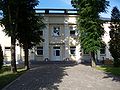
The city's Catholic church was built from 1902 to 1914 by Karl Eduard Strandmann in neo-Gothic style. Next to it is a memorial to the volunteers who died fighting the Bolsheviks in 1919 . There is a high school (with a history museum), a library (since 1937), a hospital, a post office (from 1895), a pharmacy (since 1888), a social care house (since 2006), a cultural center, a gallery "Voras" and a Motor mill. The old town of Ramygala is an urban monument.

Ramygala
hospital

high school

Catholic Church


Born in Ramygala
- Isaac Ben Jacob (1801–1863), Russian publicist and author and the first modern Hebrew bibliographer
- Ligitas Kernagis (* 1963), Lithuanian singer, musician and former politician
literature
- Ramygala. Tarybų Lietuvos enciklopedija , T. 3 (Masaitis-Simno). - Vilnius: Vyriausioji enciklopedijų redakcija, 1987. 500 psl.