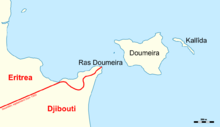
Ras Doumeira
| Ras Doumeira | ||
| Geographical location | ||
|
|
||
| Coordinates | 12 ° 42 '46 " N , 43 ° 8' 10" E | |
| Waters 1 | Red Sea | |
Ras Doumeira is a cape northeast of Djibouti near the Bab al-Mandab in the Red Sea . Together with the island of Doumeira , 500 meters further north-east, the cape has been the subject of a border conflict between Eritrea and Djibouti since Eritrea's independence from Ethiopia in 1993 .
The southeast coast is a long beach up to a few hundred meters from the cape. The northwest coast is rockier and has a bay with a beach.
The border was determined at the end of the 19th / beginning of the 20th century between the then Italian colonial power Eritrea and the French colonial rulers of Djibouti, but according to some experts this was only vague. When the Sultanate of Raheita was divided up in 1901 , Italy and France agreed that no third country should control Ras Doumeira and that border issues should later be regulated more precisely. However, Djibouti is of the opinion that a treaty of 1897 clearly assigned Ras Doumeira to France and thus to present-day Djibouti. Eritrea, on the other hand, relied on a French-Italian agreement of 1935 that was never ratified .
From the point of view of Djibouti, the island and the cape belong to the Alaili Dadda district of the Obock region and form the northernmost part of the country.

