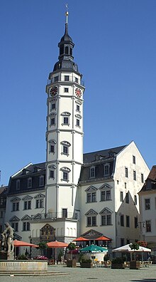
Town hall Gera
The Gera town hall is the seat of the city administration and the city council in the independent city of Gera . It consists of several connected buildings between the market and the Kornmarkt .
history
According to later tradition, the small town had its first town hall as early as 1254. The first written mention of it dates from March 30, 1425. The building was destroyed in the Saxon Civil War of 1450, but was rebuilt using old parts until the first handed down town charter (1487).
In the years 1573 to 1575 today's town hall was built in the Renaissance style. Due to the strong resemblance to the Altenburg town hall , it is assumed that it was designed like this by the master builder Nicol Gromann from Torgau. On October 14, 1575, the construction of the town hall was ceremoniously completed with the installation of the tower button. The old pillory is located near the passage between the market and the Kornmarkt, the so-called bread bank (where a restaurant is now located) . In its current form, it dates back to 1754.
When city fire in 1780 the Town Hall was badly damaged, but the walls could be obtained, so that it has been largely restored to its original 1783/84; only the previous gable on the market side was omitted. In 1793 a two-storey extension was added to the back of the town hall, on the Kornmarkt.
In 1911/12 the town hall was extended by a new building, also located on Kornmarkt, connected to the old town hall, the so-called New Town Hall . The two entrance portals are modeled on the Badertor , which was demolished at the end of the 19th century, and was the last Gera city gate.
In 1973, the cabaret Fettnäppchen was opened in one of the town hall cellars ( Höhler ) .
portal
The town hall portal was designed between 1573 and 1576 by Nicol Teiner from Lobeda and two other stonemasons. The double-headed eagle of the Holy Roman Empire is depicted in the portal gable , including the coats of arms of Reuss and von Solms . The latter is a reference to Dorothea von Solms-Sonnenwalde , who at that time reigned over her underage son Heinrich Posthumus Reuss .
Under the coat of arms of the nobility, flanked by two Latin inscriptions, is the city coat of arms (shown reversed). The three male figures inside the archway are interpreted as the three mayors at the time it was built. At that time Gera had a threefold council, each of which provided a mayor and which took turns with government affairs every year. The carving on the door wing depicts the ancient Roman goddess Justitia with her attributes blindfold, scales and sword . On the right side of the portal is the original size of the Gera cubit (0.572 m).
Türmerstube
The 57 meter high town hall tower was last inhabited from 1936 to 1939. Currently located in the 8 m 2 large Türmerstube a small permanent exhibition of historical views of the last inhabitant of the tiny watchman's apartment . The city historian and genealogist Heinz Xylander had given a selection of 9 ink drawings from his historical city views published in the Chronik Gera he created for the 3rd cave festival of the interest group "Junge Stadtführer".
The town hall tower can be climbed up to the tower parlor, which is 33.5 meters high, via a 161-step staircase as a lookout tower and from here offers a very good view of Gera and the surrounding area. A carillon with 37 bells is located in the tower lantern above the tower parlor .
See also
literature
- Anja Löffler: Monument topography Federal Republic of Germany - cultural monuments in Thuringia (Volume 3). City of Gera . Thuringian State Office for Monument Preservation and Archeology, Erfurt 2007, ISBN 978-3-937940-33-5 .
- Siegfried Mues / Klaus Brodale: City guide Gera . Gondrom Verlag, Bindlach 1995, ISBN 3-8112-0821-7
Web links
Individual evidence
- ↑ Gera Town Hall on thueringen.info
- ↑ Kommunaler Anzeiger Issue 52, December 26, 2006, p. 10: Heinz Xylander's pictures in the Türmerstube
- ↑ Around the town hall tower, Chronicle Gera, H. Xylander, 1991 Master-Print Gera
- ^ Town hall tower on the website of the city of Gera
Coordinates: 50 ° 52 ′ 34.5 " N , 12 ° 5 ′ 1.9" E


